|
present Dirt Bro Bob Goes to College! |
 |
|
present Dirt Bro Bob Goes to College! |
|
|
Bob's notes from lectures presented at Texas State University, San Marcos |
 Order the latest edition of this book direct from the publisher! |
|
|
|
|
|
|
|
|
|
|
|
|
|
|
|
|
|
|
|||
| Gallery | Latest Finds | Book Review Index | Report Typos |
| August 25
& 28,
2006
Archaeology is a subdiscipline of
Anthropology How time is notated: BC (before Christ) as 2000 BC for example, which would be 4006 years ago BP (before present, actually years before AD 1950, (the year radiocarbon dating was discovered) written as 2000 BP for example, which would actually be 2056 years ago from this year. A brief list of significant early Archaeologists: Nabonidus (died 538 BC, 2nd Neo-Babylonian Empire) is generally considered to be the first archaeologist. A religious man. He set about rebuilding temples while looking for ancient inscriptions of earlier kings. One such place Nabonidus excavated was Ishtar. Nabonidus “looked to the physical residues of antiquity to answer questions about the past.” And then there was the Renaissance (1300-1700) when time periods were beginning to be grouped into the Medieval, Classical, etc. Point being that there was an intense interest in “things past.” This was also the age of exploration and the discovery of the New World. Petrarch and Dante are considered the fathers of the Renaissance. Petrarch was Italian but mostly wrote in Latin and promoted the study of human thought and action, part of his humanist philosophy. Petrarch idolized the past and created a great deal of impetus to study the past, to investigate it, and thus he stimulated a rediscovery of classical thought. Establishment of the formal discipline of archaeology is credited to Ciriaco de’ Pizzicolli who, inspired by ancient inscriptions he found on monuments believed and promoted the idea that they provided a more direct testimony of antiquity than literary tradition alone. He was a hands-on dirt archaeologist and also promoted the need to see physical remains. When asked what he did for a living he famously replied, “Restoring the dead to life.” Interest in the classics and the past led Bishop James Ussher to calculate from biblical texts, the day the world began as Sunday, October 23, 4004BC. The 18th and 19th centuries saw a rise in the idea of deep time, the deep past, origins. Around this time Jacques Boucher de Perthes, interested in this “deep time” and in the origins of humans, observed that old stone tools he found in rivers at the time were the remains of tools used by ancient mankind. Remember that during this era, 1in 1859, Darwin was working on his theories of evolution. Anthropology at this time defined everything in euro-centric classic terms. There also began an intense interest in the “disappearing” Native Americans’ origins. Settlement on the Ohio Valley continued to find large earthworks and mounds. People believed that the present Indians killed off another race of more European-like peoples who were the actual moundbuilders. Anthropololgists thought Native Americans were primitive cultures since they were not occupying the large abandoned moundbuilder towns. By the end of the 19th century there developed the ethnographic approach to looking at other cultures. Researchers began to see that the mound builders were indeed the ancestors of the Native Americans they knew. Rise of Americanist Archaeology: Some Early American Archaeologists C.B. Moore (1852-1936) was a wealthy antiquarian, an early term for what can at best be called collector/avocationalist. Moore did early scientific work, exploring the Southeast US by steamboat, probing the many waterways of the area. He took notes, made maps, and more importantly, when he found a burial, made measurements and rudimentary analyses of bones, and he published his results. Nels Nelson (1875-1964), definitely not a wealthy man, worked his way across the US from Scandinavia, wound up in Arizona where he did extensive fieldwork. He did what could be considered the first formal modern excavations using analysis of stratigraphy to determine chronology. Alfred Kidder (1886-1963) earned the 6th PhD awarded by an American university. Kidder is best known for the chronologies he created around his examination of the humble potsherd, or fragment of pottery. He identified different motifs and associated them with different cultures. He was able to show that by doing this he could reconstruct cultural trade patterns as well as chronologies. He is best known for his work at Pecos Pueblo in Arizona. James A. Ford (1911-1968) examined pottery from the SE US. He invented seriation, a statistically based-chronology system still part in use today. Ford was part of a generation still focused on culture history (focus on a history of a particular area through time) and on the chronology of artifacts. This perspective, called adaptive perspective emphasizes technology, ecology, and economics in defining human behaviors. Walter Taylor (1913-1997) was an upstart grad student who, in his 1948 dissertation critiqued the entire culture history approach. He suggested that researchers move away from the grand and spectacular, ie, excavations of temples and such, and try to look at the lives of ordinary people: to excavate dumps and small houses. He furthermore reproached researchers for their lack of scientific approach and urged them to test hypotheses, use statistics; to excavate less extensively and more intensively and to bring in specialists, if necessary, an interdisciplinary approach. Taylor’s dissertation was a call to revolution! Lewis Binford (1930- ) put it all together into what was called the New Archaeology in the 1950’s. also called processual archaeology. He pointed out that research needed to be able to explain kinship and cultural interactions from scientific perspectives. Archaeology Research Theory and Perspective 1. Ideational Perspective is thought-based and non-material. It defines ideas, symbols and mental structures as driving forces in shaping human behaviors; 2. Adaptive Perspective emphasizes technology, ecology, and economics in defining human behaviors. Franz Boas spent considerable time studying a northwest tribe called the Kwakiutl, who were well-known for their potlatches. The potlatch is a means for an otherwise egalitarian society to have individuals show-off by throwing feasts where much is wasted and destroyed on purpose. If we apply both perspectives to the
potlatch,
we would find: 2. An Adaptive view of the potlatch would focus on the materials and how they assisted in the creation of alliances, and would look at the environs – salmon runs are variable and potlatch might be easy way to allay some starvation and create alliances for other times of need – sharing alliances. It is usually best to approach an observation from both perspectives as each will underscore different, important, sometimes fundamental truths. top of page SCIENCE is defined as a search for universals by means of logical, verifiable (reproducible) inquiry. Scientific research proceeds from the making and testing of hypotheses Wikipedia defines “hypothesis” in this way: “A hypothesis is a suggested explanation of a phenomenon or reasoned proposal suggesting a possible correlation between multiple phenomena. The term derives from the ancient Greek, hypotithenai meaning "to put under" or "to suppose". The scientific method requires that one can test a scientific hypothesis. Scientists generally base such hypotheses on previous observations or on extensions of scientific theories.” We can see the evolution of Americanist archaeological method and theory by looking at pioneering American archaeologists and how they evaluated a problem: The Origin of the Moundbuilders.
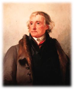
THOMAS JEFFERSON Jefferson spent some years investigating the many mounds that were found in Virginia. He hypothesised that the many burials found in the mounds were the result of warfare. Many people believed that Native Americans of his time were those who massacred the “superior” race who had built the mounds. Jefferson testing his hypothesis and using stratigraphy, excavated and analysed the bones he found. Finding the bones of children present, and finding no trauma on many of the bones convinced Jefferson that he had excavated burial mounds of ancestors of Indians of his time. He published his findings in “Excavations by Rivanna River” in 1782, later republished (1784) as “Notes On The State of Virginia”, the only full-length book Jefferson ever published. After the Revolution more mounds began to be discovered in the Ohio Valley attributed to a race of vanished people massacred by Indians. Because of a lack of historical context common to European classical archaeology, this myth was believed through the 19th century. American nationalism was used to perpetuate the idea that this mythical race could have been European in order to establish long foundations of inhabitance—the Indians were in the way of western expansion. So, despite Jefferson’s fine work, the myth prevailed. Ephraim Squier (1821-1888, a surveyer) and Edwin Davis (1811-1888, a physician), when they weren’t feuding, did excellent survey work on mounds which became, when published in 1848, the Smithsonian Institute’s first publication, Ancient Monuments of the Mississippi Valley. Unfortunately, all of that fine work surveying 200 complex sites only further convinced Squier and Davis that the Indians could not have constructed the mounds. The question of who built the mounds
entranced
the public and became a huge popular topic. Thomas was about to use a more formal approach to archaeological problems, and unlike Squier and Davis, start off his investigations with an explicit question: “Were the mounds built by the Indians?” Thomas was actually a proponent of a separate race of moundbuilders but after spending 12 years studying data from over 2000 sites in 21 states, he was forced to conclude that “the author believes the theory which attributes these works to the Indians to be the correct one.” Researchers previous to Thomas used a direct historical approach in their work. In this approach you start with what is known and, by working backwards, supposedly discover facts/understanding. However the research questions, as posed, are frequently loaded with cultural and political bias. Cyrus Thomas used the Scientific Method to solve the moundbuilder myth. The Scientific Method (assumes nature is
ordered): Parts One and Two, require Inductive Reasoning wherein the facts as known are stated as premise for the suggested phenomena as yet unobserved. Some important things to remember about science is that it is self-correcting: even bad research/assumptions/hypotheses are “found out” through use of deductive reasoning and if-then statements, sometimes called bridging arguments. Example: If the mounds were built by a long vanquished race, then they should be considerably older than the known Indian culture. Science is also reiterative, or cyclical: hypotheses give way to facts which give way to more hypotheses. And finally, science is not infallible: Facts alone can be inherently biased—for example, data sets, which are chosen by the researcher, might selectively contain only variables favorable to the outcome of the research. There is another means of looking at problems, another approach, Humanism. The Humanist Approach focuses on human interest and values and looks at individual experiences. The Humanist researcher finds fault with the scientific approach, finding it sterile. The humanist approach to a problem would also look at ideological, religious, political and economic factors within a problem, taking an Ideational Perspective toward the problem. The purpose of research is to create theory. Theory is an empirical (objective) answer to a “Why?” question. Another way of defining it would be as an explanation for an empirical (observed) phenomenon. There are THREE Levels of Theory: LOW LEVEL theory contains observations and interpretations gained from hands-on work, i.e., raw data (observations made on excavated items); MID-LEVEL, or Mid-Range theory contains the hypotheses which link data with human behaviors or natural processes. Examples of this kind of theory would be inquiries into Experimental Archaeology, Ethnoarchaeology, and Taphonomy (explanations of natural processes such as erosion); HIGH LEVEL, or General theory seeks to answer large “Why?” questions—cosmological ones, for example. In order to create theory, or to do research, a researcher must understand the overarching PARADIGM from which he/she sees the problem. A more formal definition: The overarching framework, often unstated, for understanding a research problem—often a personal viewpoint of “how the world works”. There are two major paradigms in archaeology: Processual and Post-Processual. The Processual Paradigm attempts to explain social, economic and cultural change as a result of adaptation to material conditions and emphasizes evolutionary generalizations and regularities. This paradigm is embedded within Cultural Materialism which uses material things (environmental, technical, economic, population, subsistence) as determinants of human behavior. Cultural Materialism focuses on behavioral events as opposed to mental events which can be observed only indirectly. Cultural Materialists examine three fundamental concepts: INFRASTRUCTURE (food, shelter, sex (and reproduction), health) gets the most focus and priority. As example, there would be slight differences between the infrastructures among hunter-gatherers v/s agricultural-based sedentary groups; SOCIOCULTURAL processes are made up of interpersonal relationships that emerge as behaviors: domestic economy, means of production, housing arrangements, family structures, political economy (organization of reproduction, exchange, trade); SUPERSTRUCTURE represents a societies values, aesthetics, rules,, beliefs and symbols which are manifested as art, music, dance, literature, games sports, and even science. The processual paradigm is cultural materialism applied to the study of the past. Archaeology and the world at large was profoundly affected by the 2 World Wars, the rise of terrible technologies, continuations of human suffering. Previous attitudes toward society placed great promise on the idea that societies are ever evolving toward states of increasing perfection. History proved otherwise and there appeared on the scene philosophers like Kierkegaard and Nietzsche, and writers like Rene Descartes and Albert Camus, people who began to doubt that science and technology would or could solve humanity’s problems, or that there existed a set of universal truths to discover. Postmodernists showed how colonialism constructed our set of biases and assumptions about other cultures. By the 1960’s we see the rise of deconstruction, an effort to expose how these assumptions tainted what was supposed to have been objective and systematic searches for knowledge. Anthropologist Richard Wilk showed that our perceptions of Maya culture, and indeed research conclusions, were directly related to cultural situations present in the researcher’s culture at the time papers were published! Postmodernists argue that our understanding of the world is not really The Truth but rather, that truth is a subjective product of the time in which a person lives. Americanist Archaeology in the 1960’s and 70’s biggest influence came from the United Kingdom came in the person of archaeologist and statistician Ian Hodder. Hodder coined the term post-processual paradigm to describe a focus which rejects the scientific approach and is more concerned with interpreting the past rather than in testing hypotheses. Post-processualism is embedded within Post-Modernism. Presently, we have archaeologists such as Michele Hegemon who profess to practice post-processualism+ , perhaps best thought of as a little of both worlds, a kind of middle of the road approach. top of page ARCHAEOLOGICAL METHODOLOGY Doing archaeology consists of two methods: Surveys and Excavations. The Archaeological Survey can reveal important
information: Archaeological Excavation reveals: Survey and excavation decisions should be guided by the
research questions
(hypotheses) being asked. Researchers MUST think ahead---> Field
strategies
are important because excavation is destructive. Researchers get but
one
chance to excavate an area. A survey’s objective is to find the precise location of sites: their size; kind of site; and distribution of other sites within space. Survey procedure: A researcher can use aerial photography. This type of survey is not systematic, will give little detail and is good for finding sites but not artifacts. In addition, the researcher will need to groundtruth the sightings (will still need to get boots on the ground to verify observations.) THE SYSTEMATIC SURVEY (as opposed to Gumshoe Survey) The aim is to find the full-range of human settlement in an area. A large survey area is very expensive to completely (100% survey) and researchers are usually forced to survey and excavate only a percentage of the area, say 10%--- to do this STATISTICAL SAMPLING is used to minimize and eliminate subjective bias in areas chosen to work. This type of sampling can sometimes miss the large and unusual, even a pyramid, or a huge structure could be passed over, but sampling is designed to get a representational sample of what is common, not unusual in an area. The sample universe is the entire region to be sampled. Its size and shape are entirely determined by research questions being asked and also practical consideration of the landscape. The sample fraction, or percent of the area to be sampled is also determined largely by the same issues as the universe. Finally, sample units are the survey units of standard size and shape which will be distributed in the fraction. Survey strategies: Simple Random surveys are comprised of a random “hat-pull” of grid squares arrayed across entire region--- may leave significant areas without any survey/excavation. Stratified Random surveys ensure a more distributed coverage of survey/excavation by dividing up known subsections of the sample universe into zones, then taking a % of each section to survey with similar hat-pull technique. top of page SHORT CASE STUDY (not in textbook) Julian Steward and David Hurst Thomas studied a large region in Nevada known as the Reese River Valley. Thomas used a land-use model based on ethnographic data collected by Steward who surveyed Shoshone who lived there historically. Steward interviewed Shoshone about their grandparents and parents who lived there during the 1920’s and 30’s. The Shoshone traveled a seasonal round about the valley to exploit different resources available different times of the year there: Winter villages were at middle elevations where they could exploit wood, sheep, piñons and berries. These sites were occupied for the longest period of time and were the biggest sites, therefore, the largest varieties of activities take place. After winter, groups dispersed and lived along the Reese River where they could exploit rice grass, antelope, etc. They could also regroup occasionally for ceremonies, such as the fandango (200-300 people) and to group hunt such as in rabbit drives. All of this information, when put together is called a SETTLEMENT PATTERN and to discover it one needs to do a STATISTICAL SURVEY. Steward was criticized because he extrapolates from “modern” ethnographies and there was argument about what he found as being relevant to post-contact culture and not earlier. So, to Thomas, the problem was whether the settlement pattern Steward discovered used prehistorically. Thomas predicted (inferred) that therefore, by the river there should be evidence of fishing and in open scrub there should be evidence of the gathering of seeds. So, Thomas needed to look for artifactual evidence to support his contentions (such as fishhooks, weights, nets, or baskets and grinding stones, etc.) Thomas created stratified zones to search: River, Arid/Sagebrush, Piñon, Upper Sagebrush. He broke these zones into 500M squares and then surveyed 10% of those zones. Thomas found the Steward’s ideas did indeed have some validity through the near past of a couple 100 years, but that different routines held sway in previous eras. He summarized his ideas into what he called a central base wandering system. PROBLEMS WITH SURVEY DATA Older sites are harder to find--> they could be buried, or there could have been environmental changes (climate and vegetation) which could have destroyed these sites: Site visibility and obstrusiveness. top of page WHAT IS A SITE, ANYWAY? Defining a site is a difficult proposition though we tend to define it as discrete behavioral entities. But surface sites are not really easy to define as villages, camps, etc. Sometimes only a few sherds or flint flakes are found as scatter and can too easily be called a site. Site deflation, where water or wind blows or washes away fine sediment which can combine strata from several time periods, can muddle site information. Instead of using sites as a unit of data, we can use artifacts. By mapping all artifacts in an area with a total station, we can get precise x.y.z coordinates for every artifact in what can be a large area. Then patterns can possibly be discerned and clusters of artifacts can be defined, ie, sites, by artifact distribution. But this approach is not practical for large regions. An alternative to this method is known as non-site archaeology, which focuses on concentrations of artifacts from an entire region and not from individual sites. In this way, artifacts excavated from an entire zone within an area are lumped together and analysed rather than trying to interpret an assemblage from one isolated concentration within a more or less continuous distribution of debris. Sites are easiest to define when they are cities or villages. All states record archaeological information in terms of sites and archaeologists recive funds to study sites. What’s important is that the archaeologist have a more realistic understanding that sites are but a sampling of perhaps a larger, wider phenomenon. Ancient surfaces are not always visible and can be buried deeply, under as much as 30-40m as in the Jackson Lake area of Grand Teton Park where sites are under just such a depth, beneath glacial till (the mixture of rock and earth pushed along the front and side of a glacier). Years after extensive surveys have mapped an area, huge floods can expose hundreds of sites no one had imagined existed and the site will need yet another extensive survey. Bottom line: surface archaeology, in surveying only the surface, can miss a lot of data. And so, archaeologists do plow-zone archaeology by walking freshly plowed fields and finding what the plow has brought up. Shovel testing, digging a series of systematically chosen small circular holes (usually 15cm dia.) and sifting content at arbitrary levels (usually 10cm), looking for buried archaeological remains. Holes are always back-filled after examination. GPS & Modern Surveys These days, most anyone who performs a survey takes advantage of Global Positioning System (GPS) technology. GPS units work by picking up the continuous signals from up to 12 (four are minimally needed) and triangulating a position by using the delay between transmission and reception of the signal from each satellite. GPS is funded by the government, who launch and maintain the 27 satellite system. The “birds” orbit the earth every 12 hours in 12 evenly distributed orbits. GPS units will track the user no matter what course he/she wishes to follow, making it unnecessary to plot transects… saving much time and money. The Full coverage survey, is where100% of an region is surveyed in a systematic, intense examination of a large section of terrain. Places such as the Valley of Oaxaca were subjected to this type of survey. Deciding on how big a survey should be done in an area needs to be determined before hand--- too big a survey just wastes money--- too small a survey and you will get an incomplete picture of the cultural remains of a region. Full coverage is best suited to areas with a highly visible archaeological record (there’s large and obvious buildings spread about the region) and where the topography is relatively even (deserts, arid and semi-arid regions) for optimal surface visibility. Full surveys can treat an entire region as one large site and can examine relationships between communities. In fact its most important attribute is that it can talk about specific relations between specific communities, rather than about types of relationships between types of communities. Today the most common kind of archaeology may be full coverage as most work done by archaeologists is Cultural Resource Management work done as the result of large construction projects. These projects, while not research driven, contribute awesome amounts of data. REMOTE SENSING/GEOGRAPHIC INFORMATION SYSTEMS NOTES Remote sensing refers to application of an array of photographic and geophysical techniques that rely of electromagnetic energy to detect and measure certain aspects of an archaeological target. High Altitude Imagery (aerial photography) was first tried from a hot air balloon. WWI opened up the possibility of using the technique for archaeology as the German military photographed Sinai ruins and discovered that shots taken with the sunlight at an oblique angle showed shadows and undulations in the ground surface that showed shallow buried walls. After the war, OGS Crawford and Antoine Poidebard used aerial shots to locate Roman ruins. Charles Lindbergh, on his goodwill tours throughout Mexico, Central America and the West Indies, working with A.V. Kidder, took extensive aerial photographs of important Maya ruins as well as Chaco Canyon. These photographs are still an important resource today. In fact, Lindbergh’s photos showed the extensive network of Anasazi roads but no one noticed them in the shots until the 1970’s! Today, aerial photography used advanced techniques such as thermal infrared multispectral scanning (TIMS) which measures infrared thermal radiation given off by the grounds. TIMS photos are very high quality and are analysed by computer programs which “paint” the image in”false-colors” mapping the ground in terms of infrared radiation thus rendering the terrain in contrasting colors. Items like roads are more tightly packed than surrounding terrain and therefore reflect more infrared light. Over 600km of Chaco roads were found using this technology. OTHER FORMS OF Remote Sensing Imagery Color Infrared Film (CIR) detects wavelengths at and beyond the red end of the spectrum. CIR can record differences in vegetation and can find therefore, buried features. Requires clear and cloudless skies. Synthetic Aperture Radar (SAR) uses radar beams to locate buried features because hard buried surfaces reflect more energy than soft surfaces--- in 1982 was used by space shuttle to penetrate Saharan sands to look for ancient waterways. Landsat Multi-Spectral Scanner (MSS) like TIMS, taken from the old Landsat satellites, but of much less resolution (only 80 meters). SPOT, a French-based satellite image system that can record one or more bands of the spectrum to achieve a resolution of only 2.5 meters. It is unaffected by cloud cover and shadows and SPOT data can be produced as 3-dimensional images. Proton Precession Magnetometer is a remote sensing technique that measures the strength of magnetism between the earth’s magnetic core and a sensor controlled by the operator. Magnetic anomalies could indicate the presence of buried walls or features. The readings are taken across a systematic grid and a computer plotter generates a contour map reflecting both the shape and intensity of the anomalies beneath the surface. Soil Resistivity Survey is a technique that monitors the electrical resistance of soils in a restricted volume near the surface of an archaeological site—buried walls or features can be detected by changes in the amount of resistance registered by the sensor. Works best in slightly damp soils as areas of high resistance drain off water slower and therefore, by their retention. Areas of human occupation activity increases ion content of the soil, thus reducing resistivity. Ground-Penetrating Radar is a sensing technique in which radar pulses directed into the ground reflect back to the surface when they strike features or interfaces within the ground, showing the presence and depth of possible features. An expensive, but speedy technique, GPR was first developed in1910. GPR indicates changes in the density of dirt, groundwater, buried objects, voids, or other interface between soil and rocks. A researcher will use transducers (a device that converts electrical energy to electromagnetic waves) of various sizes which can direct the greatest degree of resolution to the depth of specific interest. A pulsating electric current is passed through an antenna, inducing electromagnetic waves that radiate toward the target and return within a fraction of a microsecond to be recorded. As the antenna is dragged across the ground surface, a continuous profile of subsurface electromagnetic conditions is printed on a graphic recorder. The location and depth of subsurface targets can be inferred from, and tested against, this graphic record. GPR works best when the soil resistivity is high, such as in well-drained soils and those with low clay content. Sub-surface wells, foundations, cellars, voids, cavities and well-defined compact zones (such as house floors) can provide clear radar echoes. Potential and Limitations Non-Invasive (Remote Sensing) Archaeology Remote-sensing is expensive, but like all new technologies, the costs are coming down as the tech becomes more pervasive. However remote sensing will not work in every environment—in places where there is a lot of background noise, such as a high ground water table, or natural subsurface features, it is often difficult to pick out which anomalies in the magnetometer, resitivity, or GPR readings are worth investigating. High altitude photography needs to be ground-truthed with physical observation to determine what’s really on the ground. Geographic Information Systems (GIS) GIS consists of three primary components: a computer graphics program used to draw a map; one or more external databases linked to objects on the map; and, a set of analytical tools that can interpret or statistically analyze the stored data. In GIS, a database is composed of several layers, or themes. This can be compared to a base map and a set of mylar plastic printed maps which can be used to overlay the base with other data, sat vegetation, or known communities, etc. All of this information taken together is referred to as a georeferenced database because it is all referenced to a common mapping reference (the base topo map for example). Each data point on the map can contain all of the relevant data for that point—for example, a site referenced on the map can link to information about the site’s artifacts, site size, slope, and the kind of architecture which is present. The database can also be queried for distances to water sources from any point, and larger queries about the region, such as pueblos within any set distance, can also be posed. GIS can even create a viewshed that shows what portion of the landscape is visible from a particular site. The predictive capacity of GIS can be shown in projects such as done at the Aberdeen Proving Grounds where it was used to spot and protect archaeological sites on its 39,000 acres of weapons testing ground. Since the proving grounds are on marshy and filled with possible unexploded shells, conventional means of survey were either too expensive or dangerous to conduct. Using predictive models and GIS, maps were developed that allow the Army to locate facilities and plan tests with the least amount of damage to archaeological sites. Landscape Archaeology is another use of GIS technology. Landscape, for this purpose is defined as “the material manifestation of the relation between humans and their environments.” GIS was used in an examination of Chaco roads as part of a landscape archaeology question which asks whether they were constructed as tools for the distribution of food between pueblos, or whether they were constructed for other, religious and representational uses. GIS analyzed whether the roads followed the “least-resistance” paths between areas--- i.e., whether they took the easiest path across or around hills, etc. Analysis showed that the roads passed many important shrines and did not take the paths of least resistance, therefore the roads had some symbolic meanings still unrecognized by archaeologists. top of page EXCAVATION Artifact —Any moveable object that has been used, modified or manufactured by humans. Ecofact --- Plant or animal remains found at a site (includes copralites). Feature — Immovable structures, layers, pits (firepits, hearths) and postholes, which are discovered during excavation (can also be found on surface). The objective of excavation is provenience, an artifact’s exact spatial location and context within a site. THE GUIDING RULE OF ALL EXCAVATION is to record context of all artifacts, features, etc. IN-SITU (in position). Preservation is always an issue in excavation. Preservation of the artifacts in-situ AND preservation for curation. Good in-situ preservation requires at least 2 of the
following: Each area, or zone of an excavation has a datum point, or zero point, a fixed reference used to keep control on a dig, usually controls the vertical and horizontal dimensions of provenience. Excavation is performed in square pits called units (usually 1m x1m, or 2m x 2m)and using horizontal excavation units in natural or arbitrary levels. Natural levels are the site’s strata (more or less homogenous or gradational material, visually seperable from other levels by a discrete change in the character of the material—texture, compactness, color, rock, organic content—and/or by a sharp break in the nature of the deposition). Arbitrary levels are the basic vertical subdivisions used when easily recognizable natural levels are lacking--- set by the researcher, arbitrary levels can be 10cm or any set amount. Arbitrary level excavation requires more analysis than natural levels as any 10cm level could contain artifacts from several time periods as the natural ground level could slope and cut into several of the arbitrary levels. Excavators use site excavation forms to record all observations made during the dig at each level. A level grid is used to plot artifacts and features as they are found. The judicious use of a camera to record photographs throughout the excavation is essential. Anything found in each level is bagged and tagged appropriately. Organic materials are carefully removed, labeled and stored for future analysis, their exact proveniences recorded on the level form. All soil, as it is removed from the pit, or unit, is sifted and materials of interest also stored in baggies and labeled according to level. In most digs, lithic flakes and organics such as snails and shell fragments are also saved to be counted and sorted in the lab. Water screening is sometimes used when the matrix is sticky or when the artifacts are expected to be very small and can be lost in clumping of soil. Most excavations use ¼” and 1/8” screen mesh to sift soil excavated from a unit. When in doubt that organics or other samples are being completely discovered, a sample of bulk soils can be saved and water sifted at a later time. This is called matrix-sorting. Flotation is sometimes used to find small organics, such as burned wood/charcoal, seeds and pollen. Soil is poured in to water, the soil sinks, and the plant materials float up to the surface. This fraction is skimmed off and examined under magnification. Everything that comes out of an excavation is catalogued
carefully
according to a catalog numbering system setup by the principal
investigator. top of page SITE FORMATION PROCESSES Geoarchaeology, according to Michael Waters (Texas
A&M Univ.),
is defined as “the field of study that applies the concepts and methods
of the geosciences to archaeological research.” Waters believes that
geoarchaeology
has two objectives: STRATIGRAPHY Steno’s Law of Superposition AN EXAMPLE OF STENO’S LAW used in the field: This was important because, if the strata could be dated, then the footprints could tell us not only when the hominids walked there, but if old enough, they could be the oldest bipedal human footprints ever discovered. And if the footprints were older than the oldest known stone tools at the time, it would disprove theories that tool use led to bipedalism, which was the prevalent belief in the 50’s The footprints were in the deepest level of observed strata at
the site.
The following is a list of the strata at Laetoli: (yougest to oldest) There was no evidence of grass at the Laetolil lens base, so researchers concluded that the volcano which produced the ash erupted in the dry season, futhermore there is evidence of raindrops on the ash, and further on evidence of erosion from heavy downpour, all leading the scientists to believe that the ash, called Footprint Tuff had been laid down over a short few week period-- > all this information based strictly geological information alone! Using K-Ar (pottassium argon) dating, the footprints dated to 3.5 million years ago (mya), much older than the oldest known stone tools made 2.5 mya. ANOTHER EXAMPLE OF STRATIGRAPHIC ANALYSIS Alluvial sediments (gravels to silts) are those carried by flowing water and deposited as water drained away. Eolian sediments are those blown and deposited by the wind (sometimes spelled aeolian). Colluvial sediments are materials deposited by gravity; material lying on hillsides. Distinct stratigraphic layers are those which are known across a region, say from a large volcanic eruption which took place at a known date… these are called Marker Beds. Gatecliff contained such a volcanic marker bed (Stratum 55) and this aided in dating the strata above and below it--- Stratum 55 was identified as ash called Mazama (6900 years old) so all strata below it are older than 6900 years old and those above are nore recent than 6900 years. Also important are the soils found in strata. Soil is defined as sediments that have undergone insitu chemical and mechanical alterations. Soil is not, by definition, considered a depositional deposit, but can be present as distinctive layers that form in place. The A Horizon is the topsoil, a dark humus layer. It’s
the upper
part of a soil, where active organic and mechanical decomposition of
geological
and organic material occurs. Problems with Stratigraphic analysis. Reverse stratigraphy is "flipped layer logic" caused when later activity, such as the digging of a barrow pit over the top of an older deposit--- the dug out soil would contain older deposits, which would now be utilized above where it was originally left. This would not only cause the dug out older materials to be out of sequence, as the original deposit would now be discontiguous also, the barrow pit would fill in with newer materials that would intrude upon the older deposit! WHEW! This situation occurred in Chetro Ketl, in Chaco Canyon (near Pueblo Bonito site), where many people over successive years lived on and modified the land. top of page CONTEXT and Site Formation In trying to figure out what a site was used for we must not forget that the archaeological record is only the contemporary evidence left over from past behavior. The archaeological record is also rarely a direct reflection of past behaviors--- a lot can happen to a site in the intervening years between occupation and the present. Michael Schiffer (University of Arizona) distinguishes two
types
of contexts which need to be understood: Four distinctive processes in the systemic context that influence archaeological site formation: 1. Cultural Deposition is the dominant way items get
deposited.
Four ways things get deposited are Discards, Loss, Caching and Ritual
Internment; Five distinctive processes affect an item once it has entered the archaeological context: 1. Floralturbation is the kind of movement, or
disturbance, caused
by plants—tree roots can easily be seen as possible disturbances to a
site; An example of disturbance being deduced from observation was at Cagny-l’Epinette, a cave in France where it was thought a pristine occupation layer was found around 3 meters deep… after analyzing the orientation of all artifacts and non-artifacts found in the level, it was determined that they were oriented along the same axis as the flow of a nearby stream and therefore washed into the cave over time from a site upstream. They were aligned in an arrangement caused by a process called imbrication: a fluvial process through which stones in a stream or riverbed come to rest overlapping like shingles on a roof, with their upstream ends lying slightly lower in elelvation than their downstream ends. HOW TO GET A DATE--- Building a Chronology There are two kinds of expressions of dates: 1. Absolute dates are expressed as specific units of
scientific
measurement, such as days, years, centuries; absolute determinations
attempting
to pinpoint a discrete, known interval in time; Relative Dating Methods 1. Law of Superposition (described above)—in short,
“What’s on
top is younger.”; Oscar Montelius (1843-1921) adapted the index fossil concept for archaeology by studying collections of European artifacts, seperating them by unmixed contexts when possible… ultimately he “divided the Bronze, Neolithic and Iron Ages into chronological subdivisions, each with its own set of distinctive artifacts or artifact styles, such as particular types of axe heads, swords, or brooches. Montelius used other relative contexts, such as stratigraphy, where available, to decide which artifact styles were earlier or later. But, he also made assumptions about an artifact's “complexity”, ordering types from “simple” to “complex”. His “Logical progression” ideas simply do not work in archaeology where an item does not reproduce, and ideas come from people (such as potters) who do not necessarily follow convention. Montelius may not have gotten it totally correct but he gave archaeology a good example to build upon for creating time markers. It took Nels Nelson to find a deep enough stratigraphy in which there were significant artifact deposits in order to marry the law of superposition with the index fossil concept. What he wanted to create was a master sequence, and Nelson found what he was looking for in Pueblo San Cristobal, New Mexico. He composed a chart relating arbitrary depth levels (1ft-10ft, in 1ft intervals) to frequency counts of 5 types of pottery. Now there was a way to place other sites, strata and features in the region into a chronological order. Kidder used Nelson’s methods at Pecos. Now archaeologists could date other sites by the types of pottery found in them, and they could say one site was older or younger than another by comparing the pottery assemblages found at the sites. (Note that you couldn’t say exactly how much younger or older a site was than another.) This all evolved into seriation, first defined by Alfred Kroeber as a relative dating method that orders artifacts based on the assumption that one cultural style replaces an earlier style over time. With a master seriation diagram, sites can be dated based on the frequency of several artifact styles, i.e., ceramic styles. This technique depended on the idea that styles change over time, that they gradually fade out and are replaced with the next “cool” stye to come along. So, while the index fossil concept depended on the absence or presence of artifact types, seriation depends upon frequencies of artifact types relative to each other. Seriation charts have shapes which are called popularity curves or, as James A. Ford called them, “battleship curves”, looking as they do like battleship top-profiles which winnow in and out.
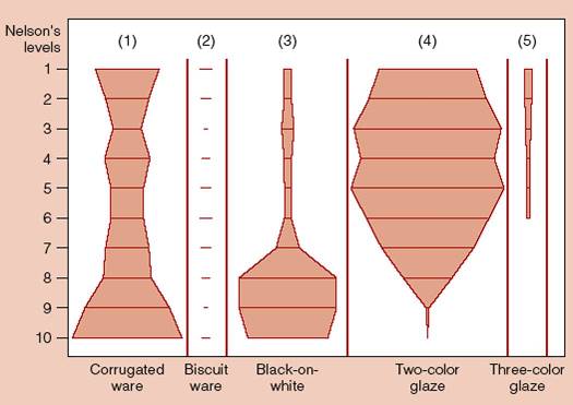
top of page ABSOLUTE DATING TECHNIQUES Tree ring dating, or Dendrochronology, was developed by astronomer Andrew Douglass (1867-1962) in the 1920’s, is based on the observation that in winter when trees are dormant, dark rings appear in cutaways of trees, and during spring growth periods the tree makes light rings. The thickness of tree rings indicate rain periods. Trees are "cored" and those cores studied. To use tree-ring dating successfully, one needs to build a
master
chronology which is regional and by species. The best species of
tree
for the region or area studied must be chosen carefully--- you need
trees
which will best indicate changes in weather, for instance. Living trees
are examined (do not use trees by rivers), recent stumps, for example,
and the researcher will try to find an overlap point on the rings and
work
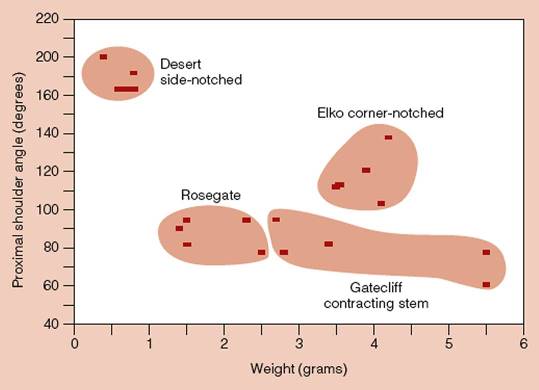
backward in time…. There must be at least 20 visible rings in a sample for the method to work. Also, since the outermost ring is the tree’s age, there must be no damage to it. Since young trees grow at different rates a mathematical function was created that converts a tree’s rings into a standard index that takes the tree’s age into account. This technique will not help you if the culture you are studying used old wood, i.e., reclaimed it from an abandoned structure. This technique is inexpensive and very accurate—University of Arizona charges about $20 per sample. RADIOCARBON DATING Discovered by William Libby (1908-1940) in 1950, even though it is not as precise as tree-ring dating, radiocarbon dating is the most widely used dating technique. Libby won a Nobel Prize for this discovery. Of the three groups of carbon isotopes (C-12, C-13, and C-14) C-14 (having 14 electrons) is the rarest, being that only one atom in a trillion is C-14. It is formed as nitrogen loses a neutron, and is then oxidated to form CO2, which is them absorbed by most every living plant and then into animals (herbivores, first, then carnivores). C-14 decays and is replaced regularly withing living things, but decays to C-12 over its half-life when a living thing dies. The half life of C-14 (Cambridge Half-Life) is 5730 years. In other words, one-half of a dead organic’s C-14 will decay every 5730 years. So, a sample is burned, converted to CO2, where the C-14 atoms decay and emit an electron, which is counted. For more information--look here: http://id-archserve.ucsb.edu/anth3/courseware/Chronology/08_Radiocarbon_Dating.html Dates are given in radiocarbon years, not calendar years, because C-14 decays at varying rates. An RC date is given as such: Beta-122854 6510 +/- 70 BP. The first part of the date is the lab name and sample number, the second part is the date with range of uncertainty. Dates are Before Present (which are computed from 1950, i.e. 500 BP = AD1450)--- sometimes dates have RCYBP after them to indicate Radiocarbon Years Before Present. So, in the example above, tha sample’s age falls between 6440 (6510-70) and 6580 (6510 + 70) RCYBP. Radiocarbon dating is only good for specimens younger than 40,000 years old. All samples are not equal! A lab must know as much about the sample’s origin as possible. Plant materials such as maize, contain more C-14 than other materials and will appear younger than, say oak, because it absorbs more C-14 than oak does. The Reservoir Effect occurs when marine samples, say of snails, accumulate quantities of “dead” carbon from limestone into their diets, thus seeming to be older than they are. However, labs can calibrate and correct for these errors. Tree-ring dating was used to corroborate the accuracy of radiocarbon dating. When this was tried, it was noticed that the radiocarbon dates were off slightly. It was noted that C-14 is apparently present in different quantities in different parts of the world (one reason is that there’s more ocean in the southern hemisphere, affecting the C-14 absorption of anything in that hemisphere-- most of the supply of C-14 is absorbed by the world's oceans)---these fluctuations are known as the deVries effect, and are also corrected in the lab. All radiocarbon dates need calibration to a calendar year, and labs routinely report the calibrations to the researcher. Standard radiocarbon dating requires a relatively large sample size and costs about $320-340 per sample to analyse. More advanced AMS (Accelerator Mass Spectrometry) requires a smaller sample (down to milligrams, depending upon type of sample), but costs three times as much money, over $1000/sample. However, some samples, such as bone materials which use collagen for analysis, are almost always analysed with AMS. Two examples of RC dating used in important research: How old is Egyptian agriculture? RC dating was used to show that a small sample of seeds found at deep levels and indicating a radically earlier date for the start of agriculture in Egypt, proved to be considerably younger than the surrounding materials through RC dating… proving that the seeds somehow washed down through the strata. Examinations of the Shroud of Turin proved the cloth could not have been the burial shroud of Jesus. TRAPPED CHARGE DATING A class of dating which includes three major processes: This somewhat complex dating process counts the amount of trapped electrons in mineral crystal lattices. Gamma rays (and some other forces) alter an electron’s spin and energy levels over time, trapping more and more of them over time… assuming that the rate is constant, if we could count the number of trapped electrons, we could measure the amount of radiation dose the sample has undergone over the years and could calculate a specimen’s age by dividing the speciman’s accrued rate of dose by its annual rate of dose. Annual doses are measured by leaving a dosimeter at an archaeological site and collecting it a year later. Trapped electrons can be returned to their normal enery levels by heating them, or exposing them to certain light frequencies, causing the entire trapping process to begin anew. Thus trapped charge dating identifies the last time a specimen had its "traps" emptied. So, context is very important with this form of testing… if the specimen had been burned at any time since its internment, this would affect the process. Trapped charge dating is possibly accurate for items as much as 300,000 years old! TL is used for the examination of ceramics, testing the temper substances, such as feldspar and other minerals used to strengthen the pot. Buried samples are frequently compared to surface finds. TL can quickly determine whether pottery presented to a museum is a fraud. It is also used to analyze buried stone tools, and has been instrumental in Neanderthal research. OSL is a trapped charge technique which can date sediments; the age is the time elapsed between the last time a few moments of sunshine reset the clock to zero (trap release) and the present. ESR is used to examine tooth enamel, it can date items much older than RC dating and therefore has been useful in dating teeth and stone tools from Neanderthal times and older. Trapped charge methods are very expensive, costing approx. $1000/sample. POTTASIUM ARGON (K/AR)and ARGON-ARGON (AR/AR)ANALYSIS K/AR and AR/AR dating are useful in dating the formation of a particular layer of the rock itself. The method measures the decomposition of K-40 to Argon gas (Ar-40). AR/AR measures the amount of AR-39 and AR-40, usually present in volcanic ashes. These radioactive isotopes have extremely long half-lives and therefore are only useful to date specimens of 400,000 years of age or older. It was used to date the Laetoli footprints, by examining the marker bed which contained the footprints. Since the method dates when the layer was formed, special care must be taken to insure that the layer contains no argon gas. The more AR-40 present in a sample, the older it is. These methods approach the accuracy of RC dating, however, they are much more expesive, costing $700/sample. DATING IN HISTORICAL ARCHAEOLOGY Other techniques: Mean Ceramic Dates – a statistical technique for combining the median age of manufacture for temporally significant pottery types to estimate the average age of a feature or site. top of page PREPARING SPECIMENS FOR ANALYSIS Washing, when applicable, will bring out details (such as maker’s marks and/or colors and patterns). Washing in water is obviously not for baskets and other materials that might be damaged or decompose, or where important residues might be washed away. Washing is a step some archaeologists pass over entirely, favoring the possibility that there are indeed precious residues on the artifact’s surface which need to be conserved. Stabilize/Conserve items which are fragile and possibly decomposing. Sometimes this is done in the field with coating and other sorts of chemical stabilizers. This step is usually necessary for items such as old bone, wood and paper or weavings. GENERAL STEPS IN LABWORK Albert Spaulding pointed out that “archaeology is about patterns in artifacts and features through time and space.” Organizing data into meaningful spacial and temporal patterns is then, by inference, perhaps the first task in understanding observations made in the field.. Labeling, Bagging and Tagging. This is an obvious step, some of which is done in the field and includes the compiling of a catalog of artifacts, as well as the drawing and photographing of lab specimens. It is important to be sure to use acid-free paper for any documents—failure to do so will result in decomposing records! Acid free paper should always be used for the wrapping of artifacts, if necessary, and for the same reason as decomposing paper creates chemicals which will affect items wrapped in it. TYPOLOGY Typing and sorting of materials is an important diagnostic tool used in the lab to sort out what’s relevent about any kind of artifactual assemblage. Recall that Albert Spaulding's comment that “archaeology is about patterns in artifacts and features through time and space.”However, trying to decide what patterns, or specific attributes of any item should be noted, and which attributes and item, or class of item should things be classified by, is just as important as deciding what to collect together into an assemblage in the first place. Identifying important patterns to track and classify by is called space-time systematics. A Type is a class of artifact defined by a consistent clustering of attributes. These attributes are abstractions and relevent only for study and are not meant to reflect ancient values. What types one creates is directly tied to, and dependent upon the research question at hand. Morphological types are those related by shape and overall similarity. They are merely descriptions, however, and do not relate to function. In description, raw material is then usually followed by shape, for example, “bone, disc-shaped with two drilled holes.” Temporal types are those associated by specific temporally-defined (chronological) meanings — they are the time markers. If a type occurs exclusively in a particular dated strata, it can be elevated to a temporal type, thus, if an item matching the temporal type turns up in an undated context, it can be assigned hypothetically, the date of the temporal type it matches. Functional types are artifacts related specifically by their use. This type will undoubtedly contain items which also fit other temporal or morphological types. Thus a category of knife, would include knives made of many materials and from many time periods. RULES OF TYPOLOGY 2. The typology must be objective and explicit--- it must be reproducable by any trained observer. Once artifacts are typed, they must be placed in time and across space…. This means the types are treated as hypotheticals needing to be tested and refined based upon observations made in specific spaces, i.e., at sites in the field. As an example, we can look at research done at Gatecliff Cave. Here were found many projectiles, including many types of stemmed, notched projectiles. By choosing the appropriate attributes (a detail such a weight, length, barbed, etc., see illustration below) the archaeologists were able to type each and every projectile they found. In their case, the projectiles all had varying types of notching, both side and corner, at all kinds of angles. Once they chose a characteristic called “proximal shoulder angle (PSA)” and contrasted this data with weight, they were able to immediately see a clustering of items into types which fit the rules of typology. The researchers were able, after analysing the projectiles, to create a projectile point key and then to use the key to create a chart showing relative proportions of selected projectile point types across stratigraphic units. What researchers did next was to plot the 5 distinct types seen above by level distribution within the “living floors”, or horizons, that they were found in, looking for significant morphological changes… those types which underwent significant changes became temporal types for the site. SPACE-TIME SYSTEMATICS (from Textbook, not
covered in lecture) "As the chronologies of different culture areas were worked out, prehistory was organized into slices of time that were given different names. Archaeologists divided prehistory into periods based on gross changes in easily observed archaeological remains, such as subistence, or house forms." (examples: Paleoindian Period, Archaic Period, etc.) "Major cultural transitions, such as the appearance of ceramics, settled life, or agriculture, were labeled horizons... this kind of cultural horizon might have different ages in different regions. Maize, for example, was first domesticated in southern Mexico... and gradually spread north... this horizon appears progressively later in time as we move" northward. "This concept is not heavily used today because of its association with an outdated evolutionary paradigm and because we now know that many transitions, including that from hunter-gatherer to agriculture, were not as quick as the horizon concept assumed." So, as we can see artifacts, such as pottery, change over time but at different rates in different places; i.e., temporally and spatially. These changes were originally organized into period and horizons. These days, archaeologists work with phases, which are defined as "an archaeological construct possessing traits sufficiently characteristic to distinguish it from units similarly conceived; spatailly limited to roughly a locality or region and chronologically limited to the briefest interval of time possible." Phases are constructed of temporal types, or time-markers. Clusters of assemblages of artifacts (assemblages defined as all of the artifacts from one specific unit of provenience, perhaps an individual level) are looked at as components (defined as an archaeological construct consisting of a stratum or set of strata that are presumed to be culturally homogenous. Components are site specific, from a single site! A set of components from various sites in a region will make up a phase. "The construction of phases allows archaeologists to synthesize reams of data into a series of (admittedly simplistic) time-slices which, in turn, can be compared and contrasted with similar schemes from neighboring areas." Phases are assigned provisionally, expanding or contracting with the uncovering of further data. Phases tell us nothing about why certain time-markers changes or developed, because time-markers deliberately ignore cultural behavior. "It is only after documenting temporal and spacial change that we can set about reconstructing what people actually did in the past." Tools useful for typing artifacts: Once all of this labwork and analysis is completed, items need to be curated, or placed in permanent storage. Everything must be placed in acid free cartons, labeled carefully, or placed in curation drawers, depending upon the facility, which is usually totally environmentally controlled. top of page LITHIC ANALYSIS & PRODUCTION TECHNIQUES A Brief History of Lithic Tools: Earliest stone tools manufactured 2.5 mya by Homo Habilus in Olduvai Gorge in Tanzania. H.habilus occupations found in 70 different locations. Called Oldowan, H.habilus tools are mostly cobble tools which became ubiquitous by 2 mya. H.habilus sourced their flint materials from as far as 6 miles (10km) away from habitation. They may have made bone and/or wood tools we have yet to find. Why did humans begin to make tools? Toolmaking is possibly associated with increased importance of meat in the diet. Perhaps tools were made to aid in scavenging efficiency with tools that could make getting to nutricious bone marrow easier. We know they were cutting meat because use-wear analysis of flake assemblages tells us so. As an example, one analysis of nine flake blades found at a habilus site: of the nine blades, four held a polish associated with meat cutting, three with sawing wood, and two were for cutting plant matter. About 1.5 mya, Homo erectus made the more complex Achulean handaxes. These tools were similar to Oldowan but with a more complex design which took more forethought. These are multi-purpose tools and the type most associated with erectus. And finally, we get the incredible complexity of the Early Upper Paleolithic Blades of Homo sapiens sapiens found in Europe 40,000 – 20,000 years ago. Projectile technology took a leap forward with the production of Clovis points. Unique to North America and produced 13,000 years ago, Clovis points are classic spear points and used a unique fluting technology. They are indicative of the rise of specialized tools and specialized class of toolmaker. The later Folsom variety was even more sophisticated and thin. The technology of toolmaking gives insight into clues about subsistence and a cultural view of how people felt about the materials. For example, the Maya created eccentric blades which could not be used for practical purposes, but instead were made as ritual offerings. CONTEXT is therefore important in determining tool function. CHIPPING/FLAKING TECHNOLOGY Stone tools are made by a Reductive technique whereby flakes are removed from raw material, which is reduced in size and is shaped. Techniques of Flint Knapping Percussion flaking is generally accomplished by hard-hammer and is done early in the reductive process, creating the basic shape of the stone tool. Pressure flaking is accomplished by “pressing” or “pushing” flakes off the edges. Flakes are usually very small, thus, pressure flaking was mostly used in final sharpening and/or re-sharpening of edges. Brittle, fine-grained materials work best for the manufacture of stone tools. Materials such as flint and chert would frequently be heat treated to further improve their brittleness. Some definitions: Core - the main chunk of stone from which flakes or blades are struck. There are three kinds, or classes of cores. Flake -- the length is typically less than 2 times the width (L<2W) Blade -- the length is typically greater than 2 times the width (L>2W) and it has parallel edges. Cortex -- the outer, weathered rind of a stone. The presence and amount of cortex indicates the kind and stage of manufacture. TYPES OF CHIPPED STONE ARTIFACTS Frison Effect is one in which stone artifacts undergo a change in shape from resharpening activities, which could affect their typing-- used to re-examine the 5 types of Mousterian (middle paleolithic; Neanderthal tools) scrapers found and typed in the early 20th century by Bordes. top of page MIDDLE RANGE RESEARCH DISCIPLINES Archaeologists must infer behaviors from the remains of those behaviors… they after all, cannot see the behaviors of people from the past. These inferences must be based upon some kind of logic, and archaeologists use the logic of geology as geologists also must determine behaviors, albeit of the earth, from only the remains of those actions (glacial movements, for example). A Scottish geologist, James Hutton (1726 – 1797) perceived what is called the principle of uniformitarianism, an analogy which put simply means that geological processes, whether in the past or present, are identical. Middle range theory “tries to make an analogy more certain by explaining why there is a necessary relationship between an object’s or feature’s attributes and an inference made from those attributes.” Formal analogies are those regarding similariites of form-- i.e., projectiles are the same form the world over, therefore, all stone projectiles have the same function. Relational analogies entail formal similarities, but
the archaeological
or ethnographic cases are also related in some way-- i.e., two
desert-adapted
cultures are related by the nature of their cultures and indeed may
entail necessary
links between attributes or features and their interpretations. So, archaeology has middle range theoretical disciplines, those which explain relationships between archaeological remains as observed and behavioral processes, whether geological or human. Archaeology’s Middle Range Research disciplines: Experimental Archaeology – Controlled experiments meant to duplicate ancient behaviors. This research is useful in testing physical and chemical processes, generating hypotheses, and giving insight into prehistoric processes. Examples: Ethnoarchaeology – The study of living societies in order to compare results of behaviors to archaeological record--- best for creating hypotheses for further research. "If generalizations cannot cover contemporary behavior, then they cannot be used to interpret the evidence of ancient behavior." Examples: Binford demonstrated that archaeologists couldn't uncritically assume that a difference in artifacts reflects only a difference in culture becuause he found the same individuals leave different kinds of tools and bones at different locations--- Border (neanderthal scrapers) had argued that different tool assemblages found at different sites equalled different Neanderthal tribes. Thus, systemic context (behavior) cannot be observed independently of the archaeological data. Other hypotheses, such as, site function, have to be tested and discarDed before inferring use of the site by different cultures. Kelley studied the Mikea habitations in Madagascar with an eye to distinguish different levels of nomadism (foraging, part-time farming; seasonal farms; year-round farms) archaeologically, and noted house post patterns of the four kinds of houses people lived in, features outside of houses, and the layout of their villages (these related to the types of nomadism directly.) He studied their trash disposal. He also studied their seasonal rounds. Kelley then took these observed patterns, extrapolating them, he used them to analyze older, prehistoric sites. Kelley's research question: "Are the different lengths of stay reflected in the material remains left behind at these sites?" He studied 30 settlements of the Mikea for 3 years. Observations of modern peoples homes and hearths, for example, could explain site formation and how artifacts get into the ground. Researchers even come back to aboriginal village sites a year after they were abandoned to see what remains. Drawbacks of ethnoarchaeology include assumptions that the past is like the present; physical places show different patterns over small periods of time. Taphonomy – the study of natural processes for comparison within archaeological sites… Examples: studying carcass bones from modern kills and
comparing them
to bones found at archaeological sites in order to determine whether
humans
were butchering animals. A 9500 year old Plains site, the bison bone beds at the
Hudson-Beng
site in Nebraska holds remains of over 500 bison—21 chipped spear
points
were found in the remains. The researchers studied the carcasses of large animals and could make comparisons to the bison to figure out how they “fell apart”. It was ultimately determined that as the bones decompose they begin to accumulate sediment which at one point leaves the top of the cranium exposed where sunlight and wind erosion processes eventually break it up and blow the small pieces away. Therefore, the bison kill was not from human attack, but likely from bison trapped by weather or some other event, which then died and decomposed. Studies of animal bones associated with early hominid camps determined that the hominids were scavengers. This was determined by examining the cut marks on ancient bones and comparing them to teeth and gnaw marks, as well as butchering marks. Cut marks over teeth marks would indicate scavenging. By removing all patterns which occur within a site from natural causes, one might better understand an archaeological site and thereby better isolate and understand the human behaviors that took place there. top of page CERAMICS Stages of manufacture: CLAY + TEMPER = PASTE Next, water is added to the paste, and it is rolled and pressed until it is free of bubbles of air which would explode if heated. Next, a vessel is formed. In the Old World a potter’s wheel was used; in the New World, pots were hand formed of either coiled clay or sheets of clay (slab). Coiled clay is superior to slab technology as it adds strength to the walls (having more than one attachment point). EARLIEST POTTERY WAS INCISED OR PUNCTATED and is similar in style the world over. Tools used for production of pots are anvils (for smoothing), pointed objects for incising, as well as combs and other pattern-makers. Paint was developed later, and added also before firing. DRYING is an important step--- “Wet” clay will explode in oven, as water will vaporize, and trapped gas wants out! FIRING OF POTTERY In America, open pits were used… pots were placed under rocks and fire was placed above, wood piled in teepee fashion around rocks and lit. Two kinds of open firing were used: True kilns are closed features, like ovens. Earthenware is an example of low temperature firing, while porcelain is high temperature fired. Why was pottery made?
"Real" pottery dates from about 12,000BP and was used for boiling and storage and/or water transport. It took less time to manufacture pottery than to make the formerly used baskets for the same purposes. Pottery , though it breaks easier, lasts longer than baskets. Women involved with food preparation made the first pottery and became the first expert class of worker. Some of the General Theories of Pottery use and production:
Earliest pottery is from the Jomon culture in Japan: As noted, the pots were made well before agriculture, so pottery was used by hunter-gatherer cultures. In particular there is a strong early association with pottery and marine resources, possible for cooking and storage of diverse foodstuffs, which later developed into status goods for feasting and prestige. First pottery in Mesoamerica is thought to have been from the Coastal Chaiapas, Mexico Barra culture (ca 2000BC): The following is from the Dartmouth
University website: SO, Barra pottery developed after domestication of plants had
fully
matured and pottery was used for storage, but also status, display, and
trade: sophisticated luxury goods! For even more information, download this pdf file: http://www.santarosa.edu/~mbond/Early%20Preclassic.pdf HOW ARCHAEOLOGISTS STUDY POTTERY Most archaeologists study the composition of pastes which make up the sherd. Chemical analysis of the paste can identify clay used, which in turn could identify the source of the clay. Examination of the sherd under a microscope can identify the temper used and thus can also, as with the clay sourcing, track exchange patterns and cultural affiliations. Finally, the iconography can be analyzed to also assist in identifying cultural affiliations and trade patterns. top of page THE STUDY OF ANIMAL REMAINS AT ARCHAEOLOGICAL SITES Archaeofauna (faunal remains) are terms for bones found
at archaeological
sites. Faunal analysis is relevant because it could tell us something about how people subsisted, hunting pattern and technologies. But first, we must analyze the bones to determine if they might have gotten there taphonomically (through natural processes, such as being washed in to a site), or been dragged there after being killed by animals, or whether a human killed the animal and butchered it. Or even, perhaps, whether humans and animals scavenged another animal's kill, or whether animals scavenged a human's kill, perhaps at an abandoned site. Some of the kinds of things to look for would be cut marks on bones, teeth marks on bones, burned bones, or remains in copralites (whether human or animal). Some of the non-food bone items in remains to look for are tools made from bone, carvings or artwork on bone and even dwellings made from bone: at the Gravettian site of Mezhirich in Russia there is a dwelling made from mammoth bones. "If co-variant patterning can be demonstrated in faunal assemblages from favorable sites it would teach us something about the makeup of bone samples recovered with tools..." (Binford, 1983)
ANALYSIS OF BONE FOR SUBSISTANCE First, the bones must be identified and so they undergo detailed comparisons with other bones, by species. This identification is important in and of itself because a difference, say between salmon, or trout, or tuna, for fish bones, makes all the difference in the behaviors of the people who caught the fish. Salmon would be fished for in different places than tuna! This is called the taxon, identifying the taxonomy (species, genus, family, or order). Identifying the taxon depends greatly on the condition of the specimen. sometimes the bones are in such a bad state that only the size class of the animal can be determined. The bones must be identified by element (the anatomical part of the body, i.e., humerus, or sternum). "Is this bone a rib splinter, part of a pelvis", etc.? To do this, the bone is examined for identifiers such as scale and shape, then referred to a comparative collection, which is a skeletal collection of modern fauna of both sexes and different ages. Metric attributes (measurements) of bones are required when differences between bones are slight and quantification depends upon fragmentation of specimens, especially when counting the bones. Certain statistical measurements can be done, either by site, or by level count: NISP= raw count of identified bones (all
specimens) (One use of these numbers is to compute the NISP+total weight of bones and compare to meat weight tables to perhaps identify what kind of animals were killed.) Of these counts, NISP and MNI are the most commonly used. All body parts do not preserve equally well-- teeth, large, or long bones, and skulls preserve best. Older animals also preserve better than younger animals with less dense bone structure. Also, cross-species, some types of animals preserve better than others, i.e. wolf bones vs. fish or bird bones. Examining bone evidence can tell us a great deal about the
environment
of the area at the time it was occupied: Seasonality can also be determined by examination of bones. For example, looking at hand bone epiphysis (defined as the end of a long bone; initially separated from the main bone by a layer of cartilage that eventually ossifies so the parts become fused), or by examining ungulate and other tooth eruption patterns. EXAMPLE of TOOTH ANALYSIS: Shellfish also have growth rings, as they grow seasonally, and these rings can be counted. BUTCHERING Ethnicity and culture can sometimes be seen in the style of butchering... an example is in the ways chicken are cut up... KFC actually uses an Asian style of butchering for chickens. Status can sometimes be determined by the types of cuts of meats remains found--- the tenderloins and legs would have been fed to people of higher status, while other cuts would have served the rest of the population, for example. Food can collectively identify a culture and be analyzed to identify status groups and where they lived within a community (an area with a large diversity of food types could be considered a high status area). Cuisine is a relatively stable cultural artifact. Evidence of climactic changes, or hard times can also be seen by the types of food eaten, or utilized. for example, finding a lot of toe bones or other less-eaten parts of animals used for marrow extraction rather than the "prime" cuts could show that perhaps colder temperatures created bad hunting and so people were forced to eat the lesser quality foods. Evidence of domestication can be determined by faunal examination because certain morphological changes took place in animals as they were domesticated. Corraled animals, especially young animals, are afflicted by a unique combination of diseases. ZOOARCHAEOLOGY AT THE AGATE BASIN FOLSOM SITE (10,780 rcya) Frison, Roberts and Stanford first excavated the site during 40's - 70's. Matt Hill reinvestigated the Folsom component archaeofaunas. He found that all of the bison bones were deposited during same occupation--- a one-shot use of the site since the "Folsom assemblage is not large, nor is it widely dispersed; some of the remains, in fact, still lie in anatomical position." The bison bones were slightly weathered and Hill decided that the animals were all killed by the same people. Hill was even able to determine how animals were butchered, and what parts were carried off by the humans. "Hill suggested that the hunters killed most of the animals individually, relatively close to camp." The smaller animals (antelope) were carried back with minimal butchery. However, the bison were too big to carry back, so the hunters and families ate some of the bison there and then, transporting back to camp meat-on-the-legbone. He concluded that these hunter gatherers were hurting, having to hunt weekly because they apparently had no stored food. ZOOARCHAEOLOGY OF CHAVIN DE HUÁNTAR (850-200BC) What did the Chavin people eat? Some lived in the valleys and some lived in the mountains. Examination of faunal remains determined behaviors over time. Miller and Burger went to the area and studied refuse heaps and subsistence remains, and eventually estimated the "usable meat values" for each cultural phase by multiplying the MNI/phase by the average animal's butchered weight for each taxon (type of animal). Four kinds of camelids live today in the Andes and were
utilized by
the ancients: In early phase researchers determined that 1/2 of all meat came from camelids, mostly llamas which had eaten a large amount of maize, and therefore, were probably from domesticated herds. The smaller camelids were mostly vicuña. Second to llamas, white-tailed deer, followed by smaller animals such as skunk, large cats, fox, and finally guinea pigs (cuy). This indicated a period of mixed hunting and herding. Over time they noted less deer, more llamas, cuy and birds entering the diet. There was also a shift in the type of bone elements observed in their garbage. What did this mean? Earlier remains included a large amount of head and foot bones and few leg bones, but in later phases the number of leg bones began to be more common and the head and foot bones become rarer. What behaviors does this describe? Turns out that the head/feet bones are the ones most likely to survive and so will be more common where whole-carcass butchering took place... the leg bones normally would be the first to decompose as they were broken for marrow. Later on, the inhabitants of the mountain regions (puna) began to freeze-dry meat, leaving it on-the-bone (this is called ch'arki, later jerky). As it turns out, the garbage of the ch'arki makers is very different from those who traded for the food. In the puna (high mountain grasslands) where the llamas are raised and the ch'arki is made there are lots of head/feet bones as they are discarded, not needed for the ch'arki manufacture. The valley floor residents (maize farmers) traded for the ch'arki. Their garbage showed a preponderance of limb bones and vertebrae, because that's how the ch'arki was delivered to them on-the-bone. So, in the final phase of the culture, we see an increase in agricultural production on the valley floor, and an increased need for trade with the mountainous regions for meat. continued on page
two.... |
|
|
|
|
|
|
|
|
|
|
|
|
|
|
|
|
|
|
|||
Links to Class Lecture Notes
| Introduction to Anthropology | ||
| Main College Index |
| Gallery | Latest Finds | Book Review Index | Report Typos |