|
present Dirt Bro Bob Goes to College! |
 |
|
present Dirt Bro Bob Goes to College! |
|
|
Bob's notes from lectures presented at Texas State University, San Marcos |
|
|
| Gallery | Latest Finds | Book Review Index | Report Typos |
 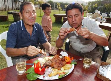 Prepared roasted guinea pig, Peru--- Yummy! (Photo credit: Martin Mejia / AP)  photo credit: http://www.amren.com/mtnews/archives/2006/11/guinea_pig_its.php October 13, 2006 ANIMAL DOMESTICATION Characteristics of Domesticated Animals: Evidence for Domestication: PALEOETHNOBOTANY Paleoethnobotany is the study of ancient plant remains when from archaeological contexts. Macrobotanical remains are non-microscopic plant remains (readily identifiable) found at archaeological sites. Examples of macrobotanical remains: corncobs, pine nuts, hearth charcoal, acorn mush stuck inside a pot. Most common means of recovering remains such as seed and small parts of plants is by flotation. (click http://www.uwlax.edu/mvac/ProcessArch/ProcessArch/lab_flotation.html for excellent pictures and explanation of flotation) Microbotanical remains are microscopic plant remains (pollen and phytoliths) found at archaeological sites. Palynology is the analysis of ancient plant pollen and spores. Pollen grains are shed by plants into the air where they eventually settle onto the ground and become enmeshed in sedementary levels over time. Pollens are collected mainly through core sampling (especially in lake bottoms) and manually from stratigraphic profiles. In the latter case a clean (washed with sterile water) trowel is used to scrape a small quantity of each stratum, starting from the lower stratum, into sealable sterile containers.Researchers create pollen diagrams by finding a statistically significant slide with 500 grains of pollen present and tabulates pollen counts to percentages and is then able to show, in the pollen diagram, the shift in pollen frequences between stratigraphic levels within a site. It is important to take samples both inside and outside of a site. (More about research methods below)
This kind of analysis can show changes in the environment. Wikipedia defines phytoliths as the following: These objects apparently serve, at least in some cases, to give structural stability to leaves and stalks. Grasses and similar plants (rice, wild rice, maize, various grains) as well as numerous tree species are just some of the plants which contain phytoliths. Phytoliths are very robust in nature, and are useful in archaeology, since they can be used to reconstruct the plants present at a site or an area within a site even though the rest of the plant parts have been burned up or dissolved. Occasionally, paleontologists find and identify phytoliths associated with extinct plant-eating animals (e.g., herbivores).
Findings such as these reveal useful information about the diet of these extinct animals, and also shed light on the evolutionary history of many different types of plants. Paleontologists in India have recently identified grass phytoliths in dinosaur dung which strongly suggests the evolution of grasses earlier than previously thought [1]. Phytoliths are mentioned in the writings of Charles Darwin." In other words, phytoliths remain to be discovered well after the plant which made them dies off... phytoliths can survive for millions of years. Phytoliths take on the shape of the cells in which they were deposited, so they can be traced to plant of origin. Although plants produce but one kind of pollen per species, phytoliths are produced in myriad forms, varying within a single species, and not all plants produce phytoliths. Phytolith research is best for determination of the abundance of types of grasses. Sometimes it is the lack of an item in the archaeological record that is more significant than the presence of a particular plant. and, although pytoliths can tell which plants were present on a specific site, pollens a re better for looking into at regional patterns. Pollens and phytoliths are frequently simply washed from pottery or grinding stones. In soil, seperate washes for each type are indicated: pollen is acid-washed from soil samples, while phytoliths must be washed out with different methods as the acid will destroy them. Paleobotanical research can reveal much information about ancient diet, seasonality, and a site's environmental history. Lipid studies are done on pottery, grinding stones and other surfaces. Lipids are materials that resist mixing with water... fats, waxes, oils. Coprolites are another item examined for the remains of ancient dinners... can tell us about diet and seasonality. EXAMPLES OF PALYNOLOGICAL AND PHYTOLITH RESEARCH Lehner Ranch Clovis Site (10,900 - 11,200 B.C.) Shanidar Cave, Iraq Did the Neanderthals bury their
dead? Did the pollen blow into the cave? Was it "background pollen rain"? The pollen was not present throughout the cave deposits, and was clumped in the shape of anthers, suggesting placement in a bunch of flowers. As it turned out, rodent were responsible for the accumulations of flower heads. After the researchers traced all of the burrow tunnels, they found the cave supported Meriones persicus, the Persian Jerd, a mouse which compulsively hoards flower heads! So much for Neanderthal religion and ritual! Discovering What People Ate in the Stillwater Marsh, Nevada (1400rcya - 1000rcya) Flotation analysis of soil samples found a large quantity of burned bulrush seeds, an easy to collect food. But did the people living there actually collect bulrush, and did the plant grow there? Bulrush, being a sedge, a grass, produces phytoliths. Phytolithic analysis amazingly showed a complete lack of bulrush phytoliths, which suggests "no bulrush plants decayed on site." Bulrush was not an uncommon plant in the region, thus this suggests that someone brought the bulrush seeds to the site as food. surveying the other seeds found on the site, it was determined that it could only have been occupied during the late summer. It was also noted that there were no remains of rice grass or piñon nuts, common foods in the region. Interestingly, in a related inquiry, wood rat middens were investigated for the existence of piñon nut, a favorite food of man and rat. It was discovered that there were no piñon nuts growing in the area prior to 1200 years ago. So the Stillwater residents were unable to eat this common food. Coprolites of Hidden Cave (near Stillwater Marsh, Nevada)
Symbolic Wood Use - Upper Mantaro Valley, Peru - AD 500 -
1500 Other important plants to an archaeologist: BIOARCHAEOLOGY
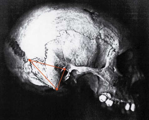
Osteology is the study of bones of all types, but of course, bioarchaeology focuses on human bones, while zooarchaeology focuses on faunal remains. Analysis of human bones found at burial sites can provide much data about ancient lifestyles. In addition, discovery of burials which constitute a burial poplulation, one which comprises burials which come from a limited region and time period, will provide more accurate inferences that burials from wider areas. Native Americans buried their dead in a number of ways, cremation, charnel house ("where the body was allowed to decompose in the open... later frequently collected and reburied in a bundle burial"), and conventional burials where bodies are ritually layed out in many ways, most common is flexed (sitting up with knees drawn up in an alomost fetal position), or unflexed (laid out lengthwise). Sex and Age are two common indicators researchers can determine by looking at skeltal remains: Sex of an individual can be determined by examination of the pelvic area, particularly, the sciatic notch, a u-shaped indention in each half of the pelvis. This region is wider in women than men (as women need the room to deliver babies)... see illustration below.
Skulss can also be used to determine sex, although "(t)he probability is that no anatomist, can be sure of sexing more than six or seven out of every ten skulls correctly." One region most studied is the mastoid area of the skull (two protrusions of bone on the bottom of the skull, one beneath each ear). Male skulls tend to be more robust overall, with heavier brows and more rugged muscle attachments. Males also tend to have squarer chins and eye orbits.
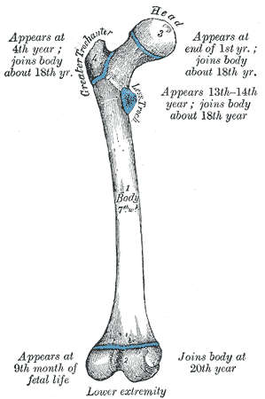
The sex of a child is the most difficult as their skulls are not fully formed for many years. Age determinants The pubic symphasis, the place where the left and right halves of the pelvis meet (see illustration above) is a good indicator of age, as it begins to wear down --- at age 20, the area has a set of ridges, that by age 35 have disappeared, and a rim forms at the edges. Patterns of bone fusion can also be seen in the skeleton's epiphyses, the ends that articulate with other bones on long bones...
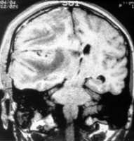
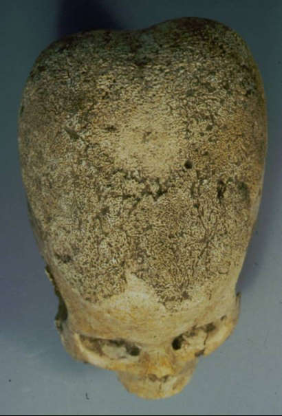
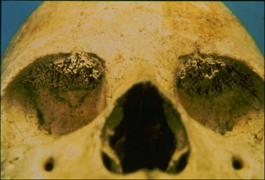
As you can see by the illustration, the epihyses grow together at set ages. Therefore examination of long bones, or bones of the ankle or writs, or fingers, can tell us how old an individual is. Tooth wear, or loss, can tell us a great deal about a person's age and diet as well. Teeth erupt at set\ times during a person's life. PALEOPATHOLOGY Chronic iron deficiencies (bad diet, parasites, chronic diarrhea are some causes) can be seen in the cranium, where, because of the lack of iron, will become spongy and develop a condition called porotic hyperostosis. The same condition, when exhibited in the eye sockets is called cribra orbitalia. These conditions result in obvious cranial deformities.
The website cited for the
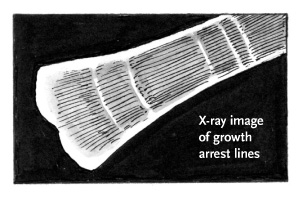
pictures above is an excellent treatise on bioarchaeology entitled: Growth arrest features, caused by occasional disease, trauma, or malnutrition during childhood years, can be seen by lines present in long bones, and are called Harris Lines:
Harris lines can only be seen using x-rays of bones. They disappear later in a person's life as the bone remodels itself and grows. A similar kind of growth arrest can be seen in teeth, called enamel hypoplasias: 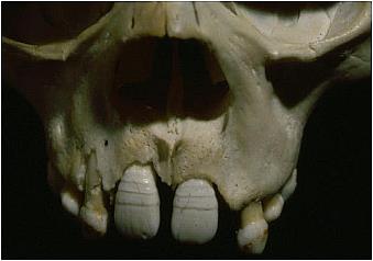 Enamel Hypoplasias (Photo copyright Clark Spencer Larsen) from http://www.cast.uark.edu/local/icaes/conferences/wburg/posters/cslarsen/larsen.html) Because teeth grow at a known rate, measurements can tell us at what age the growth arrest event took place... the width of the hypoplasia can tell us how long the growth arrest event was. These are permanent features of teeth and were present throughout the person's life. A life of hard physical workload can be seen as osteoarthritis, a joint condition often caused by repeated mechanical stress on a joint. The condition begins with bony growths, called osteophytes, which can be very painful. A complete wearing away of cartilage between joints causes a condition calle eburnation, another very painful condition. Eburnation is generally why people get hip replacements. In some cases, the vertebrae, especially in the lower back, will fuse completely.
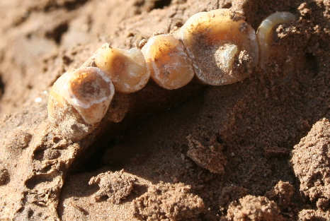
Diet can be ascertained from looking at teeth. Prior to the introduction of agricultural activities, caries, or tooth decay was very rare. Finding evidence of caries in teeth from a site can tell much about the amount of caries-causing carbohydrates, perhaps from maize, that people were eating. 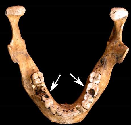 Jaw from archaeological site showing caries, or tooth decay. (photo from Hebrew University of Jerusalem) Furthermore, the amount of wear on teeth can relay information about diet and activities. When people ground grains with stone tools, a certain amount of the grit becomes enmeshed in the food, causing the teeth to wear down. This would also occur when people were eating a lot of shellfish, and other marine animals which have sand in them. Also, teeth were used to pull at leather and to chew at fibers, preparing them for weaving--- this causes the teeth to wear down also.
Other facts that can be derived from
skeletal
examinations include: 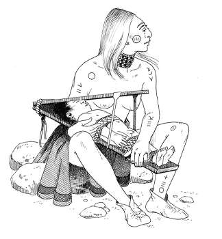 Cranial deformation of adult & illustration of child in cradle board. (illustration from excellent article on topic found here: http://edition.cens.cnrs.fr/revue/bha/2005/v23/n1-2/011573ar.html) ISOTOPIC ANALYSIS Carbon and nitrogen isotopes are absorbed along with food, and these isotopes are stored in a person's bones. Plants take in certian isotopes of carbon, notably so called C4 plants, such as maize, take in more C13 and C14 than do other plants. Human bones reflect the isotopic ratios of plants ingested during the person's lifetime. The same thing happens with meat, which contains two stable isotopes of nitrogen, N14 and N15 -- those who eat meat will have these isotopes present in their bones. Plants also absorb isotopes both through the air and through the soil... since there is a difference in the ratios between air and soil absorption, a researcher can even determine if the plants were grown through the addition of fertilizers-- i.e.-- agriculture. Examination of bones is possible through the analysis of bone collagen, the organic component of bones.A large amount of C13 and C14 present in the bones would likely indicate heavy ingestion of maize, or other C4 plants, while a heavy ratio of N14 to N15 would indicate that a lot of meat was consumed, frequently a status indicator if the bones are not from foraging communities. Isotopic analysis requires a researcher to have a lot of background knowledge about the area where the bones were found as environmental differences can cloud results. also, people whose diets included shellfish anbd other marine animals will have an altered ratio of nitrogen isotopes. Anthropology.net describes the principles of Strontium Analysis (more can be found at their website, at link above): organisms with vertebates/skeletons absorb strontium as if it were calcium. Due to the elements being sufficiently similar chemically, the stable forms of strontium do not pose a significant health threat, but the isotope allows researchers to trace environmental markers or signatures to the primary region of origin of the organism. These strontium signatures enter the body through the food chain as nutrients pass from bedrock through soil and water to plants and animals. Different geologies yield different isotopic strontium ratios. This is locked permanently in tooth enamel from birth and infancy, an important tool to trace the migration of individuals. MOLECULAR ARCHAEOLGY Three important forms of genetic materials: mDNA is useful because every cell has hundreds of mitochondria, and therefore hundreds of copies of mDNA to work with. In addition, the extant mDNA can be cloned thousands of times with use of the polymerase chain reaction technique, which means there will be plkanty of copies to analyse. Although there are many contamination issues in all ancient
DNA analysis
situations, mDNA has been used in examing the following areas:
Societies are divided into social units (groups) within which are recognized social positions (statuses), with appropriate behavior patterns prescribed for these positions (roles). Sociopolitical Organization consists of rules and structures that govern relations within a group of interacting people and includes units of social position which have their own specific rules of behavior. Social structures can be comples and include families, a town, students, etc., for example, and a person's role within it can be many-faceted as one person can be part of many groups. Two types of groups and group memberships: Burials can contain evidences of group memberships and/or can show the role of an individual in society as evident in burial goods as items buried with an individual are usually carefully chosen. High status individuals are often, but not always, buried with more symbolic items than low status individuals. Rock art, sometimes highly symbolic, can show ritual, or clan information. Political Organization Political Organization is an important function of society and is defined as formal and informal institutions that regulate a population's collective acts. In band level societies, families serve this purpose. In large societies there is a chiefdom which
determines the societies
hierarchy: In larger societies, state level societies, political organization gets even more complex. Sex and Gender social groupings: Archaeology and Gender Anthropologists distinguish between sex and gender, and between gender roles and gender ideology. Sex refers to inherited, biological differences between males and females. Gender refers to culturally constructed ideas about sex differences. Essentially, what it means to be either male or female. Humans have two sexes, male and female—but there can be
more than
two genders. In some Plains Indian tribes, berdaches ("two-spirit people") were men who chose to live as women, performing women’s roles. This was not necessarily a sexual role. Gender Role and Ideology Gender role refers to the different participation of
males and
females in the social, economic, political, and religious institutions
of a cultural group. Early research was gender-biased toward the male role as
hunter, called
an androcentric bias An example of a biased assumption would be from a burial analysis. Burials found with a mortar and pestle for instance-- frequently it waould be assumed that if found with a male, that he made them, but if found with a femaile, that she used them--- in truth these assumptions would be hard to prove. Gender ideologies can be studied by researching burials/burial goods, ceramic art, written records (can be biased) or ethnographic research and interpretations. Cargo System Part of the social organization found in many Central American communities in which a wealthy individual is named to carry out and bear the cost of important religious ceremonies throughout the year. Archaeology and Kinship Kinship refers to the socially recognized network of relationships through which individuals are related to one another by ties of descent and marriage. A kinship system blends biological descent with cultural rules that define some people as close kin and others as distant kin. In non-industrialized societies, kinship forms the main basis of one's life... this pattern extended into early State systems. Kinship is not as important in most, but not all, industrialized societies. Kin groupings condition the nature of relationships
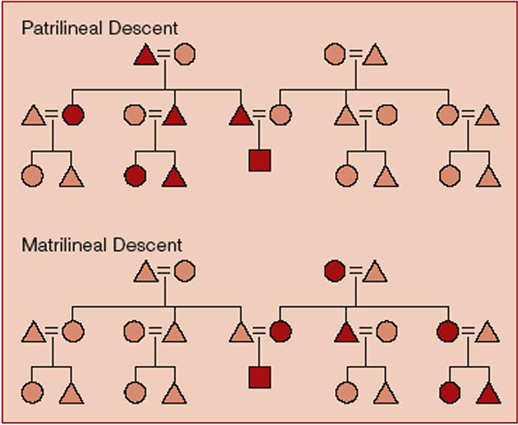
between individuals. Patrilineal and Matrilineal Descent Often it's important to know whether a society is traced either as matrilineal or patrilineal as it is lineage which controls land ownerships, not nuclear families.
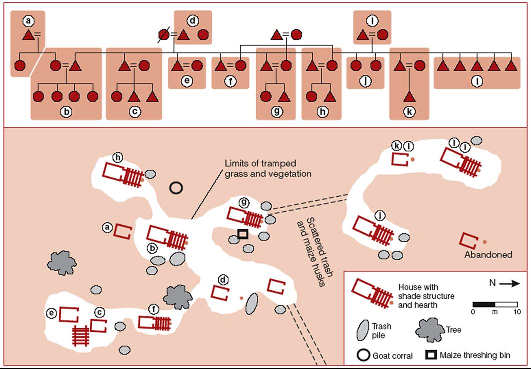
Patrilineal Descent Matrilineal Descent Mikea Hamlet Map With Kinship Chart Residence Patterns There are differences in the material remains found by
archaeologists:
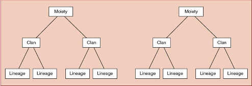
Use of strontium analysis of burial remains can show whether, for example, a woman was "local" or from another area and moved to a village due to marriage. Examination of pithouses at Chaco Canyon by Peregrine suggests that they were too small for matrilocal houses, but that later pueblos, much larger, suggest the development of matrilocal residence. "Peregrine argues the Chacoans built separate rooms, their side-by-side spatial arrangement relfecting a degree of social solidarity not seen in the earlier pithouse villages." Lineages, Clans, and Moieties
Lineages are sometimes clustered into clans, a set of
lineages
that claim to share a distant, often-mythical, ancestor. More about moieties
STATUS: The rights, duties, privileges, powers, liabilities, and immunities that accrue to a recognized and named social position. Ascribed status - Rights, duties, and obligations
that
accrue to a person by inheritence. Egalitarian Societies Small-scale egalitarian societies are called bands: A residential group of a few nuclear families, whose membership is neither permanent or binding. Relationships connect bands through marriage, etc. Band size changes often-- disgruntled groups break off and form bands of their own. Bands are usually small groups of hunters and gathers such as the Shoshone of the Great Basin-- as witht he Shoshone, bands will come together during seasonal rounds to share hunting duties as practical for them to do. The key to leadership is experience and social standing; a social position is not inherited in an egalitarian society. Thus, leadership positions are temporary and based on task-- status indicators are gender, age, and experience. Characteristics of Bands: Reciprocity is a strong function of Bands: Archaeological evidence for bands is sometimes difficult to discern. Binford established some methods for finding this evidence by studying the material remains of living hunter-gatherer communities in Arctic and Africa regions. Tribal societies represent a wide range of social formations that lie between egalitatrian foragers and ranked societies (such as chiefdoms, see below); tribal societies are normally horticultural and sedentary, with a higher level of competition than seen among nomadic hunter-gatherers. Ranked Societies Relatively permanent social stations are maintained with people having unequal access to life-sustaining resources. Status is ascribed. Economies that redistribute goods and services throughout the community, with those doing the redistributing keeping some for themselves. Chiefdoms represent the classic ranked society and are lineage-based, then ranked, with highest ranking for the Chief (source) with some political levels below. Highest ranking individuals will have differences in status and wealth and often Chiefs will have religious ties-- i.e., will be seen as "gifted from God." However, the society is not classed. Ranked societies tend to be farming communities with other specialties, but not all are agricultural as someare advanced hunter-gatherer communities with permanent residences (such as in NW US.) Ranked societies can have relatively large communities with populations from 5000- 20,000 people. There is a debate over what compromises a chiefdom, especially with the larger communities. Archaeological Evidences for Ranked Societies Death and Social Status Social ties existed between the living and the once living, and the ceremonial connections at death reflect these social relations. Mortuary rituals reflect who people were and the relationships they had with others when they were alive. Mississippian Culture (AD 800-1500) A widespread cultural tradition across much of the eastern
United States
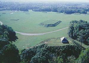
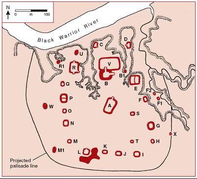
from AD 800–1500. Moundville, Alabama (AD1000- AD1450)
Covers over 300 acres and likely housed over 3000 people, with 1000's more in asscoated sites nearby. Was largest city in North America in it's time. Thgere are a total of 30 mounds. See Moundville Archaeological Park website http://moundville.ua.edu/home.html for more information, also, view Moundville:Journey Through Time, here: http://www.archaeologychannel.org/content/video/moundville.html
Evidence of long trade routes and trade goods.
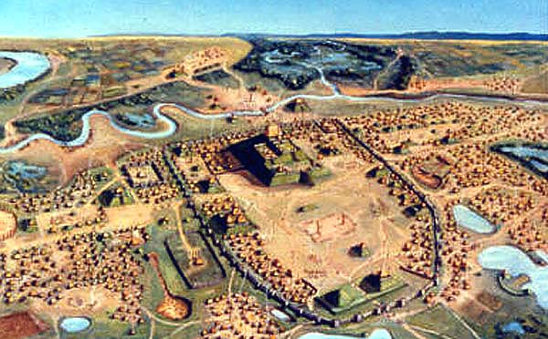
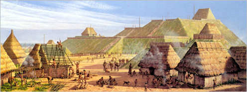
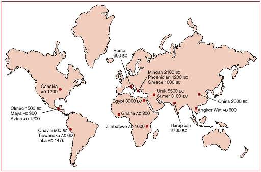
Cahokia
Over 10,000 to 20,000 people lived in Cahokia and 1000's more lived in surrounding area. Cahokia was the most complex civilization in North America. Cahokia's rulers lived on the top of Monks Mound, a 100 foot high artificial earthen platform that dominated downtown Cahokia. Monks Mound and a series of over 100 smaller platforms, temples and burial mounds ringed a gigantic plaza, and were in turn enclosed by a wooden palisade wall studded with defensive bastions. Other, smaller groups of platforms, plazas and palisades, as well as workshops, residential areas and cornfields, extended out in all directions.
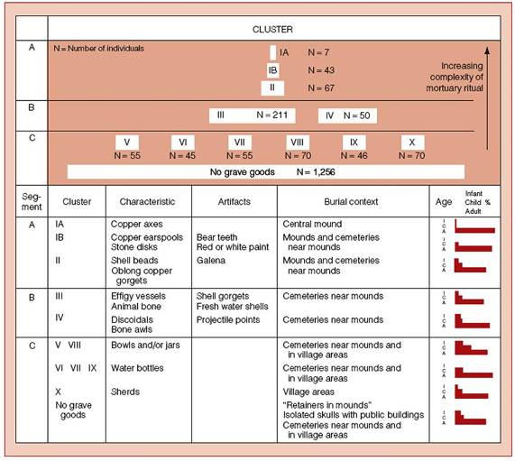
Mound 72 showed just how status was indicated in the many
burials found
in Cahokia. He was buried with 20,000 beads and 1000 projectiles Cahokia info from Wikipedia: Cahokia was first settled around 650 CE during the Late Woodland period, but mound building did not begin there until about 1050 at the beginning of the Mississippian cultural period. The site was abandoned between around 1250 and 1400. The inhabitants left no written records, and the city's original name is unknown. The name "Cahokia" refers to an unrelated clan of Illiniwek people living in the area when the first French explorers arrived in the 1600s, long after Cahokia was abandoned. The Osage, Omaha, Ponca, Quapaw and others are believed to be the descendants of the Mississippians who built the city, but no stories about Cahokia were ever recorded among these tribes. Monk's Mound is the central focus of this great ceremonial center. A massive structure with four terraces, it is the largest man-made earthen mound in North America. Facing south, it stands about 100 feet (30.5 m) high with a base 1,037 feet long and 790 feet wide (316 by 241 m). The Travel Channel has referred to it as the "world's largest pyramid." Excavation on the top of Monk's Mound has revealed evidence of a large building — perhaps a temple or the residence of the paramount chief — that could be seen throughout the city. This building was about 105 feet long and 48 feet wide, and stood about 50 feet high. "Woodhenge," a circle of posts used to make astronomical sightings, stood to the west of Monk's Mound. The name is taken from Stonehenge, as this structure marked solstices, equinoxes and other astronomical cycles. Archaeologists discovered Woodhenge during excavation of the site. They found that the structure was rebuilt several times during the urban center's roughly 300-year history. Urban landscape A wooden stockade with a series of watchtowers at regular intervals formed a two-mile long enclosure around Monk's Mound and the great plaza. Archaeologists found evidence of the stockade during excavation of the area, and indications that it was rebuilt several times. The stockade seems to have separated Cahokia's main ceremonial precinct from other parts of the city. Beyond Monk's Mound, as many as 120 more mounds stood at varying distances from the city center. To date, 109 mounds have been located, 68 of which are in the park area. The mounds are divided into several different types — platform, conical, ridge-top, etc. — each of which may have had its own function. In general terms, the city seems to have been laid out in a diamond-shaped pattern approximately a mile (1.609 km) from end to end. Ancient city At the high point of its development, Cahokia was the largest urban center north of the great Mesoamerican cities in Mexico. Although it was home to only about 1,000 people before ca. 1050, its population grew explosively after that date. Archaeologists estimate the city's population at between 8,000 and 40,000 at its peak, with more people living in outlying farming villages that supplied the main urban center. Some scholars believe that at the height of its development, Cahokia was larger than any city in the U.S. until about 1800, when Philadelphia surpassed Cahokia's estimated peak population. Prestige burial A cache of arrowheads in a variety of different styles and materials was found near the grave of this important man. Separated into four types, each from a different geographical region, the arrowheads demonstrated Cahokia's extensive trade links in North America. Over 250 other skeletons were also recovered from Mound 72. Many were found in mass graves; some were missing their hands and heads, which seems to indicate human sacrifice. The relationship of these other burials to the central burial is unclear, but it is unlikely that they were all deposited at the time of the ruler's burial. Wood in several parts of the mound has been radiocarbon-dated between 950 and 1000. Cahokia's Decline Southeastern Ceremonial Complex (Textbook notes--- not in lectures) Human Trade Systems: Down-the-line Trade Hopewell (200 BC–AD 400) A cultural tradition found in the Ohio River Valley dating from 200 BC–AD 400. The term "Hopewell" derives from the farm where excavations of an earthwork site occurred in 1891-1892. The farm was owned by a local gentleman named Mordecai Cloud Hopewell. The archaeological site of Hopewell is located on the North Fork of Paint Creek in Ross County, Ohio. "It was first mapped in the mid-nineteenth century when more
of the
ancient constructions were visible than are there today. The main
feature
of the site is the rectangular earthwork known as the Great Enclosure
that
covered about ninety-nine acres and followed the terraces of the North
Fork. Structures within the Enclosure included one D-shape that in turn
enclosed the largest mounds at the site. Mound 25 is one of these,
consisting
of three parts that when built actually covered earlier constructions.
Burials containing elaborate grave goods have been found in Mound 25."
"An extensive trade network for exotic materials existed during the period, making enormous quantities of precious objects available for use by, and burial with, the powerful people of the communities. Burials in the so-called Mound of Pipes at Mound City produced over 200 stone smoking pipes depicting animals and birds in well-realized three-dimensional form. Objects in other materials, for instance copper from the Great Lakes area and mica from the southern Appalachians, were used to create elaborate plaques, ornaments, and profile cutout images. The copper ornaments included necklaces, bracelets, breastplates, and ear spools. A sophisticated ceramic tradition produced many short, round jars that have been found in burials throughout the Hopewellian trading area." Information quoted above from Metropolitan Museum Website: http://www.metmuseum.org/toah/hd/hope/hd_hope.htm Engaged in hunting and gathering and horticulture of
indigenous plants. They constructed geometric earthworks as ceremonial enclosures and effigy mounds. Tracing an Artifact to its Source: Energy dispersive x-ray fluorescence (XRF) Uses obsidian’s trace elements to “fingerprint” an artifact and trace it to its geologic source. Instrumental neutron activation analysis (INAA) - Determines the trace element composition of the clay used to make a pot to identify the clay’s geological source. Petrographic analysis - Identifies the mineral composition of a pot’s temper and clay through microscopic observation of thin sections.
Cognitive Archaeology For obvious reasons, Cognitive archaeology is not popular with processualist archaeologists . What’s a Symbol? Symbolism is a human trait-- We live in a materialist world, but within cultures that are rife with symbolism and abstract ideas. These ideas can be different for different cultures and they can change over time--- example is in the meaning of the swastika, an ancinet symbol with positive meanings, used the world over, but because of the Nazi's use, the swastika is now loaded with negative meaning ans not used very much except by those who espouse Naziism. Archaeologists need to consider context when inferring meaning from symbols and frequently examine symbology on clithing, walls (paintings, glyphs, etc.) and in burial contexts. Hopewell Interaction Sphere A common set of symbols found in the midwestern United States between 200 BC and AD 400. Hopewell “culture” included many different peoples speaking different languages and living various ways, from the lower Mississippi to Minnesota, and from Nebraska to Virginia. These diverse people shared a unifying set of symbols that may indicate common religious beliefs. Peace pipe function and design were researched by Robert Hall
(1970's)
examined the pipe's metaphorical function which continued throughout
Hopewell
times. The pipe stylistically suggested atlatl types-- Hall suggested
that
these pipes use trancended functional and became representational of
specific
exchange/trade relationships. Religion Cosmology Iconography - Art forms or writing systems that
symbolically
represent ideas about religion or cosmology. Exploring Ancient Chavin Cosmology "The iconography of Chavin de Huantar established the tone of subsequent central mAndean cosmology. All deities of the succeeding genrations in the central Andes looked more or less like the gods in the temple at Chavin de Huantar." Interestingly, though, the people depended upon wild food animals, they are conspicuously absent from iconographic contexts. In fact, the religious iconography is filled with animals most inhabitants of Chavin would never have seen in real life, aminals from habitats hundreds of miles distant-- stylized fangs and talons, feathers and scales from the jaguar, crested eagle, monkey, serpent, and cayman (alligator). Why? First theory was that, once, the ecology of the the lowland areas was different, then supporting the animals pictured. But this did not prove to be the case, as there could be found no evidence that the lowlands could ever support ropical forests, nor could it have supported the plants and animals if they were supposedly transported into the lowlands. Second theory is that that Chavin occupies a strategic pass, or corridor, and that cjavin's religious leaders purposely imported the images of Amazonia because they believed that the people of the forest had special knowledge (a belief frequently shared by other cultures who live on the margins of large forests). Chavin's religious leaders likely made pilgrimages to the far lowlands, bringing back psychotropic plants and the tradition of the shaman. At the center of the religion was the oracle, who could pass on special knowledge. This set of beliefs was very powerful and Chavin beliefs soon spread across the Andean region. "Religious ideology seems to have played a central role in promoting and legitimizing profound sociopolitical transformations, suggesting that many of the key ingredients for social complexity existed in the central Andes prior to the Chavin horizon." Upper Paleolithic Cave Art The Upper Paleolithic (40,000–10,000 BC) in Europe is distinguished by the appearance of a complex technology of stone, bone, and antler as well as wall art, portable art objects, and decorated tools. Many Upper Paleolithic sites contain engraved, carved, or sculpted objects, and caves occupied by Upper Paleolithic peoples often contain wall paintings. Upper Paleolithic Cave Art: Content Provides vivid evidence documenting the range of animals
living in Ice
Age Europe, certain animals are emphasized (horses, aurochs, bison,
ibex,
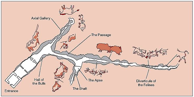
stags, and reindeer). Lascaux Cave, France The official website for the cave: http://www.culture.gouv.fr/culture/arcnat/lascaux/en/index3.html Discovered by several teenagers in 1940.
(illustration from textbook, Archaeology, click to order.) Over 600 paintings and 1500 engraved images of animals only (exception might be the bird-man at the bottom of the shaft. To see more about Lascaux, visit the official site: http://www.culture.gouv.fr/culture/arcnat/lascaux/en/
Les Troi Freres Cave in France Contains painting of a shaman--- Joseph Campbell named it "God of the Cave." He's two feet tall, and well out of reach, fourteen feet up. He presides over a swarm of bison, ibex, bear, deer, and mammoth incised on the stone slabs below him. The god of the cave is instinct and intellect and spirit in one. The full animal inheritance, and the human dance, some inquisitiveness and concern, with a nurturing hunch to his shoulders. A formidable, but not a confronting figure.  The Shaman at Le Troi Frere (Photo: http://www.angelfire.com/realm/bodhisattva/shaman-cave.html) more info: http://www.muse.or.jp/spain/eng/cantabria/castillo/castillo_top.html  Here we see abstract art from the Upper Paleolithic. (Photo from http://www.bradshawfoundation.com/cave_art.php) Structuralism Some scholars view the cave paintings as a structured code, drawing the paradigm known as structuralism. Structuralism argues that humans understand reality as paired
oppositions. Totems Shaman Vision Quests People see/experience similar things under trance or the
effect of
psychedelic substances-- A Variety of Explanations (from Lecture):
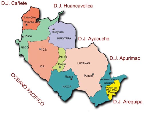 Map of Nazca Area, Peru (Map from http://www.justperu.org/peru/nazca/nazca-maps.asp#) These enigmatic features are all located in Peru, in a dry, high altitude desert with river and creek drainages to the North and South, and pampa (flat plain in the middle--- a dry landscape with little other use.
The geoglyphs all date from the Early Intermediate Period
which consisted
of three distinct cultures: 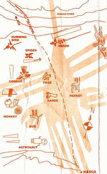 (Photo from http://www.traveladdicts.connectfree.co.uk/Peru/Nazca_lines.htm) Dating was determined through analysis of pottery sherds which frequently litter certain areas of the designs, usually at the "center" or ends of the lines. The glyphs are all made of a single unbroken line. Some of the glyph's designs can also be seen on pottery and as pottery. Lines made possible in appearance because desert is littered with reddish-colored desert-varnished stones (red from high iron content rocks undergoing oxidation)--- when these rocks are swept aside, the un-oxidised, or un-varhished pale soil below is exposed, providing a clear contrast. A Geoglyph is defined as rock art which is made in this fashion. The lines are formed into thousands of pieces of artwork which portray a range of animals from coastal to jungle varieties as well as a range of geometrical shapes from spirals to "ray centers" to trapezoids. How did the Nazcans make them so precise? But Dr. Persis B. Clarkson, an archeologist and geoglyph expert at the University of Winnipeg says the technology required was very easy and straightforward. "It was not a difficult technology... all you need is the will." As Clarkson explains, all it took was careful and diligent attention to sight lines. For the straight lines, two wooden stakes could be used to
guide the
placement of a third stake along the line. One person 'sights along'
the
first two stakes and instructs a second person where to place the third
stake. Strings could also have been used to help ensure the lines were
straight. This process could be repeated for hundreds of kilometres
with
due diligence... Why were they made? Ritual walkways have been put forth as a reason, with worshippers walking in single file through and around images. This theory is very hard to dispirove, and ritual waling might have been a part of a larger ritual ceremony. Sweeping rituals--- could keeping the lines clear and free of refuse a part of a larger ritual scenario? No one know for sure. Pointers to underground water--- latest accepted theories involve the lines running along underground water sources, and/or to exposures of water which are hidden, or difficult to find. This theory is still considered controversial. The one most universally rejected theories by all serious researchers are those which involve extraterrestrials!
Evolutionary Studies/Theories of Societal Development Unilineal cultural evolution Comparative method Natural Selection Social Darwinism Differences Between Unilineal and Modern Evolutionism Origins of Agriculture The development of agriculture was not a simple unilinear process, and agriculture, while it increased the food supply, and the population, also created many problems for humanity including obesity and sedentary lifestyle, governmental oppression, militarism, etc. THEORIES OF THE ORIGINS OF AGRICULTURE Oasis Theory Natural Habitat, or Hilly Flanks Theory Density-equilibrium Model (Population Pressure Hypothesis
(also Edge
Hypothesis by Marc Cohen) Binford argues that farming is very hard work, and that no one would do it unless there was no choice--- he offers population pressure as a reason. Agriculture would increase the carrying capacity of each acre of land farmed. Cohen further argued that agriculture was brought about by a particular crisi where food was least plentiful--- ie, the "fringe" or edge of the growth areas, where a crop grew more sparsely-- Cohen aregues that it was these areas where the first agricultural experiments were started. But neither of these ideas takes into account any social issues and stresses. Social Hypothesis Optimal Foraging Theory Coevolution Rhindos' argument ignores human intent, and the impact of overpopulation and climate change, instead arguing for a biological predelection toward agriculturalism. Peter Richerson and others argue that the environment was the key "player" in agricultural development, and that it the environmental conditions needed for agriculture were not present in the world until the Holocene-- in other words, plants were a less reliable food source than animals until around 10,000 years ago. Once people adopted agriculture, it provided a steady, reliable food source and population growth. This growth, Richerson argues, would force neighboring communities to adopt agriculture--- this pattern of behavior then spread across the globe where ever foraging "did not provide higher return rates." No one explanation seems to work for all areas, but overall, farming seems to occur in areas where only a few plants existed for consumption, and those were used only in lean times by hunter-gatherer groups as they passed through. So, they incidentally, as in coevolution theories, affected the plants which grew along their migratory pathways.
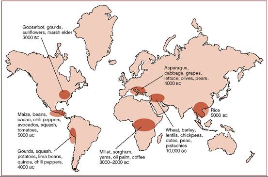
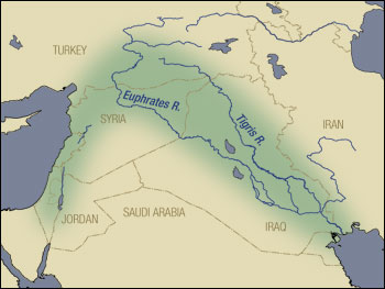
Determining domestication in plants: The Fertile Crescent
Natufian Culture, Mesolithic Era, beginning ca. 10,000
B.C., Palestine
from http://radar.ngcsu.edu/~jtwynn/Mesolithic.htm
Villagers hunting wild goats, cattle, pigs in forests and
flood plains;
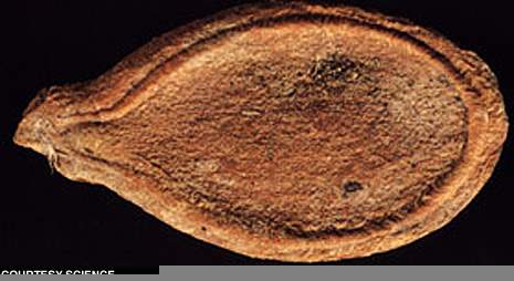
gazelle drives to hunt The Old World has sedentary foragers, the opposite of the New World. Evidences for this include grinding stones, bins, large houses, lots of animal bones (suggesting a rich natural environment), wild barley, almonds, sickle blades for cutting grasses. Evidence for the first domesticated rye is about 10,000BC in Syria, at Abu Hureyra. Neolithic (ends approx. 8000BC) Agriculture in the New World From http://www.archaeology.org/9707/newsbriefs/squash.html Earliest Agriculture in the New World Volume 50 Number 4, July/August 1997 by Spencer P.M. Harrington
"Dating of squash seeds from a cave in Oaxaca, Mexico, has
confirmed
that plant domestication in the Americas began some 10,000 years ago.
The
new finding, reported by Smithsonian archaeologist Bruce Smith in the
journal
Science, indicates that planting began in the New World about the same
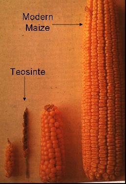
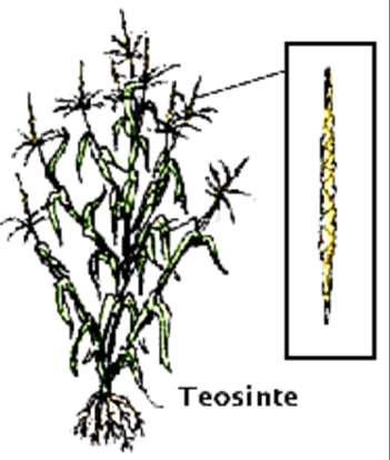
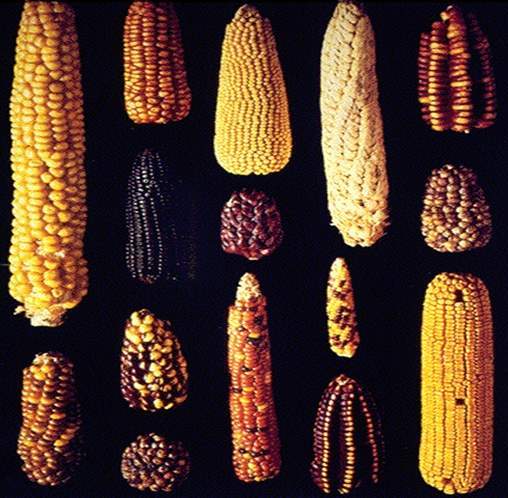
time as in the Near East and China." For more info, see link. Maize and Teosinte Maize is indigenous to Central and South America... its ancestor seems to be teosinte, which grows wild in highland Mexico. It is known that teosinte and maize have similar DNA and can be crossbred.
It is theorized that small groups of hunter-gatherers began to plant teosinte along route of seasonal rounds. Maize had little initial impact on nomadic life as development of teosinte into maize too 1000+ years. Thus the development of maize was not necessarily "purposeful", but occured as a result of harvesting the best "ears" and planting them as opposed to the seed of the sparser plants. Domesticated plant contenders all have similar
characteristics: Consequences of Agriculture Health
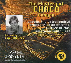
THE MYSTERY OF CHACO CANYON examines the deep enigmas presented by the massive prehistoric remains found in Chaco Canyon in northwestern New Mexico. It is the summation of 20 years of research. The film reveals that between 850 and 1150 AD, the Chacoan people designed and constructed massive ceremonial buildings in a complex celestial pattern throughout a vast desert region. Aerial and time lapse footage, computer modeling, and interviews with scholars show how the Chacoan culture designed, oriented and located its major buildings in relationship to the sun and moon. Pueblo Indians, descendants of the Chacoan people, regard Chaco as a place where their ancestors lived in a sacred past. Pueblo leaders speak of the significance of Chaco to the Pueblo world today. The film challenges the notion that Chaco Canyon was primarily a trade and redistribution center. Rather it argues that it was a center of astronomy and cosmology and that a primary purpose for the construction of the elaborate Chacoan buildings and certain roads was to express astronomical interests and to be integral parts of a celestial patterning. While the Chacoans left no written text to help us to understand their culture, their thoughts are preserved in the language of their architecture, roads and light markings. Landscape, directions, sun and moon, and movement of shadow and light were the materials used by the Chacoan architects and builders to express their knowledge of an order in the universe. above review from http://www.solsticeproject.org/films.html THE RISE OF THE STATE Major Primary Archaic States MAIN CHARACTERISTICS OF STATES Cities and Urban Environments Development of Laws and Bureaucracy Diversity of Roles Social Stratification Creation of Surplus SECONDARY HALLMARKS OF STATES Monumental Public Works-- temples, palaces, etc.
(however non-states
have them also) THEORIES OF STATE DEVELOPMENT Ecological Theory Urban Revolution Theory Critique: Chicken or Egg thing--> which developed first? Population Pressure Theory Critique: Difficult to ascertain population statistics from archaeology. The Irrigation Hypothesis The need for coordinated labor, massive construction, and so forth led to increased wealth and military strength and eventually to the powerful ruling bureaucracy that characterized state development. This early model was very persuasive because of observations made in Egypt, etc. Limiting factors of agriculture are soil conditions, temperature, water. Easiest remedy is control of water supply and irrigation systems need labor and organization. Irrigation can creaqte wealth and status for those who hold the best lands. Irrigation could have led to writing and calendrical systems, as well as roads and transport routes for trade. Basically, if one could mobilize labor for irrigation system construction (very hard work) then other mobilizations were possible. Critique: Other non-states had canal systems, such as the Hohokam, and never developed into states. There's also evidence that some states developed before use of irrigation (in China and S. America). The Warfare and Circumscription Hypothesis (Carneiro’s
Circumscription
and Warfare Hypothesis) Carniero used the development of the Moche state as example, pointing to Population growth and environmental circumscription as two conditions creating the right situation for his hypothetical scenario. In other words, here there was grood land surrounded by much arid lands... as population increased in good lands, groups were forced to initially reloacate to neighboring valleys areas (also surrounded by aird lands), eventually further population growth forces stronger group to take over each successive neighboring valley and their fields, thus forcing the development of a bureaucracy to control resources. Critique: This theory assumes no attempts to control births and downplays alliances. A Multicausal Theory This theory distinguishes between conditiona and processes that generate social change. Multicausal Origins of the Archaic State and the Mayan State
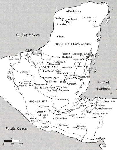
(as example): Critique: Religious, Cultural, Historical Ideology is also important-- culturally an explanation is neede for masses to mask, or lessen effect, of the exploitations of those people from "lesser" status. from textbook The Maya: A case study in State Formation We focus upon the lowland Maya, on nthe Maya who lived and still live in the Yucatan peninsula, which includes parts of Mexico, Guatemala, Belize, and Honduras.
Root of Maya culture Though it's hard to find older settlements in the lowland jungle, it's generally thought that swiddeners (slash-and-burn horticulturalists) were living there about 4000 years ago. Since they left no large buildings or elaborate burials, we can infer that they were egalitarian. Middle Pre-Classic period: Population Growth Late Pre-Classic Period: Formation of Chiefdoms
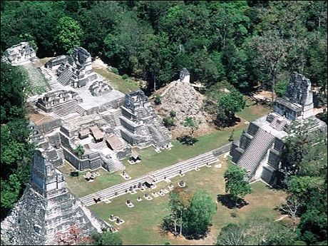
Classic Period: State Formation AD 250 - 700 The Maya had massive water control systems, moving water to agricultural areas. Keeping everyone fed was a constant chore and diets got exceedingly boring as land was producing at capacity (this between drought and flood cycles). Cities had large central plazas with rectangular ball courts
where ritual
games were played, and ritual sacrifices took place. We know that Maya courts were places of intrigue and backroom deals, perhaps like those in Medieval and Renaissance Europe, with lords and sublords plotting coups and competing for power. Iconography between AD250 and 600 is replete with images of warfare; some sites show evidence of violent destruction, such as the toppling of stelae and subsequent rebvuilding.... We know that.. by AD 700, the competition among the many centers reduced itself to a single rivalry between Tikal and Caracol (they fought for over 250 years!). Why did the Maya State develop? There's lots of information about the Maya available on the
web... here's
but one site
URUK: The First City 3500-3000BC
about Uruk (not notes from class, yet we did see a film about
this region
of Iraq) Uruk, was an ancient city of Sumer and later Babylonia, situated east of the present bed of the Euphrates, on the line of the ancient Nil canal, in a region of marshes, some 30 km east of As-Samawah, Al-Muthann?, Iraq. The theory that the modern name of Iraq could be possibly derived from the name Uruk is not proven. At its height, Uruk probably had 50,000-80,000 residents living in 6 square kilometres of walled area, the largest city in the world at its time. Uruk represents one of the world's first cities, with a dense population made up of people of a region rather than bonded by kinship as was typical of towns and villages of previous eras. Uruk also saw the rise of the state in Mesopotamia with a full-time bureaucracy, military, and stratified society. It was one of the oldest and most important cities of Sumer. It was the capital city of Gilgamesh, hero of the famous Epic. Its walls were said to have been built by order of Gilgamesh, or rather, his predecessor Enmerkar, who also constructed, it was said, the famous temple called Eanna, dedicated to the worship of Inanna (Ishtar). Its voluminous surviving temple archive of the Neo-Babylonian period documents the social function of the temple as a redistribution center. In times of famine, a family might dedicate children to the temple as oblates. Uruk played a very important part in the political history of the country from an early time, exercising hegemony in Babylonia at a period before the time of Sargon. Later it was prominent in the national struggles of the Babylonians against the Elamites up to 2004 BC, in which it suffered severely; recollections of some of these conflicts are embodied in the Gilgamesh epic, in the literary and courtly form that has come down to us. Oppenheim states, "In Uruk, in southern Mesopotamia, Sumerian civilization seems to have reached its creative peak. This is pointed out repeatedly in the references to this city in religious and, especially, in literary texts, including those of mythological content; the historical tradition as preserved in the Sumerian king-list confirms it. From Uruk the center of political gravity seems to have moved to Ur." According to the Sumerian king list, Uruk was founded by Enmerkar, who brought the official kingship with him from the city of Eanna. His father Mesh-ki-ag-gasher had "entered the sea and disappeared". Other historical kings of Uruk include Lugalzagesi of Umma (now Djokha) (who conquered Uruk), and Utuhegal. According to the Bible (Genesis 10:10), Erech, probably Uruk, was said to have been the second city founded by Nimrod. It also appears to have been the home of the Archavites, exiled by Asnapper to Samaria (Ezra 4:9-10). The sites mentioned in Ezra are all from Southern Mesopotamia, and it appears that Asnapper may be the Assyrian king Ashurbanipal, who conducted a campaign against these Southern Babylonians. Uruk was first excavated by a German team led by Julius Jordan before World War I. This expedition returned in 1928 and made further excavations until 1939, then returned in 1954 under the direction of H. Lenzen and made systematic excavations over the following years. These excavations revealed some early Sumerian documents and a larger cache of legal and scholarly tablets of the Seleucid period, that have been published by Adam Falkenstein and other German epigraphists. More Uruk notes: Later the arabs took control of Uruk. These Shia-a sect moslems carried on the sumerian tradition of lamentation and their temples were also similar to Sumerian design. Historical Archaeology The first historical archaeology in America took place
about 150
years ago. During the first half of the 20th century, historical
archaeologists
labored mostly to supplement historical records. Historical Archaeology Comes of Age Characteristics of Historical Archaeology Themes in Historical Archaeology- Reasons to pursue
it... EXAMPLES of Historic Archaeology Projects: Monticello 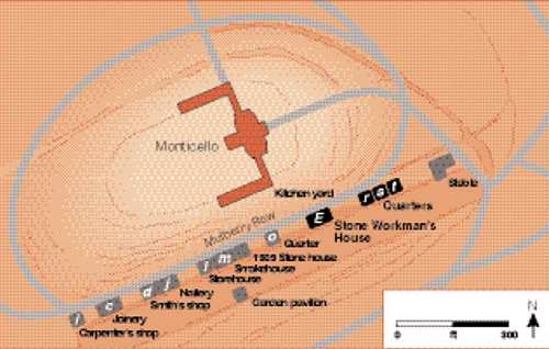 (Illustration from textbook, Archaeology, click to order.) The esearch was done on outlying areas, Mulberry Road, on 19 buildings where Jefferson's 200 slaves were quartered. Jefferson had mixed feelings about slavery, saying slavery was needed in order to guarantee continuation of the agrarian society, but felt it was morally wrong. Research question: Did he treat his slaves better than slaveholders? The study found there was a heirarchy of slaves with the elite slaves being the household slaves.. It was noted that Sally Hemmings (also Jefferson's mistress) was shifted from a large house to a small house.-- did she get a demotion? What was found was that she actually got a promotion because she was moved to her own house from a large one which had a higher number of residents. New York City's African Burial Ground In 1626, the Dutch West India Company unloaded its first shipment of enslaved Africans in New Amsterdam (today’s New York City): 11 young men. The Dutch were experiencing a labor shortage in their colonies, and found slave labor to be the answer to building and maintaining the colony. In 1664, the British gained control of NY--- An astonishing 40% of the population there were slaves. 18th century New York law prohibited the burial of Africans in Manhattan’s churchyards. New York’s African population established a cemetery outside of the city walls (Wall Street!) and from 1712 to 1790, the community buried between 10,000 and 20,000 people. (427 burials were excavated during project) In 1827 NY abolished slavery--- eventually the cemetary was built over. Dr. Michael L. Blakey’s analysis of some 400 individuals from the burial ground found that half the population died before age 12. Some were clearly worked to death: Ironically, most of the artifacts saved from the cemetary were stored at the World Trade Center-- most were fortunately recovered after 9/11. Fort Mose: Colonial America’s Black Fortress of Freedom
Both free and slave Africans were used in military operations,
a black
militia having been established in St. Augustine. Battle of the Little Big Horn Archaeologists found no evidence of skirmish lines-- this indicated chaotic placement of soldiers and not therefore an organized attack or defense. And, in fact, they also found that Custer's last stand was in a ravine and not on a hill, and furthermore, that soldiers did not fight to the end, but "froze" in fear. Medieval Mind-set Georgian Order: A worldview (ca. 1660/1680–1820) arising in the European Age of Reason and implying that the world has a single, basic immutable order. Using the powers of reason, people can discover what that
order is and
control the environment as they wish. Future of Historical Archaeology OTHER PEOPLE'S GARBAGE (a film) Protecting our Cultural Heritage Cultural Resource Management Prior to the 1960s, nearly all American archaeologists worked
for universities
and museums. 1906 Antiquities Act 1966 National Historic Preservation Act (NHPA) 1979 Archaeological Resources Protection Act Rosetta Stone 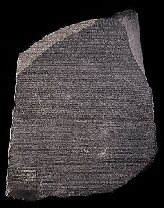 Rosetta Stone, The Breitish Museum, London A black basalt stone tablet found in 1799 that bears an
inscription
in two forms of ancient Greek and ancient Egyptian. Elgin Marbles-- 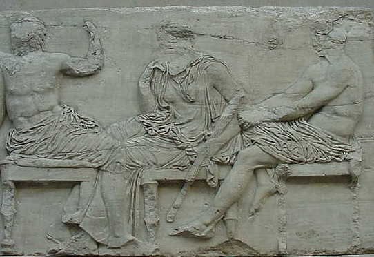 Freize 6, Elgin Marbles, The British Museum, London another very famous example of "war booty".... "The response to the Greek
government's demand for the return
to Greece
of the sculptures of the Parthenon, now in the British Museum, has been
so encouraging that it has given rise to hopes that the Elgin Marbles,
as they have come to be known, may indeed one day be restored to their
rightful home. For the time being, however, the British government and the authorities of the British Museum do not agree that the marbles should be returned. They base their stand on the argument that if the Parthenon sculptures were returned, it would set a precedent by which all the great museums of the world would ultimately have to return their treasures to their country of origin. Nevertheless, this argument cannot apply to the Elgin Marbles because they are an inseparable part of the Parthenon and cannot be compared to such things as Egyptian obelisks, pharaoh's mummies, Mesopotamian tablets or Easter Island monoliths – not even with other Greek masterpieces such as the Winged Victory of Samothrace or the Venus de Milo. Classical scholars and art historians are unanimous in declaring the Parthenon to be a unique example of Greek classical art. Those who visit it today see it without the sculptures and many are doubtless unaware that they even exist. Yet the marbles and the Parthenon, together, form part of their cultural heritage and they are prevented from appreciating and understanding its architectural value and aesthetic worth to the full." Illegal Antiquities Getty Museum curator stands trial for art trafficking Independent, The (London), Nov 17, 2005 by Peter Popham in Rome Marion True, the former curator of antiquities in California's Getty Museum, reputed to be the richest museum in the world, has appeared in court in Rome on charges of conspiring to traffic in looted art. Dr True, 57, is accused of illegally obtaining 42 fabulously valuable antiquities for the museum during the Eighties and Nineties and risks being sent to jail for eight years if found guilty. She resigned from her post in October. The trial has thrown a spotlight on the swashbuckling way some of the most famous museums in the United States have built up their collections. Paolo Ferri, the prosecutor, claims Ms True spent millions of dollars of the Getty's money to buy ancient objects which she knew to have been stolen from sites in Italy. The Italian responsible for bringing many of these treasures to the market was Giacomo Medici, who was convicted of looting and sentenced to 10 years' jail last year. He is appealing against the verdict. According to Mr Ferri, Medici's name was kept out of all the correspondence between Dr True and her favoured agents in Italy, who included a Paris- based American, Robert E Hecht Jnr, 86, who is on trial with her in Rome. But in letters sent to Dr True by her agents, the location of the objects when they were taken from the ancient sites is described in such detail that it could only have come from the tomb robbers who stole them, Mr Ferri claims. Getty
museum must return disputed art works - ROME (Reuters) - Italy told the J. Paul Getty Museum in Los Angeles on Thursday it must return all disputed art works in its collection and said the era when respected museums could get away with displaying looted antiquities was over. But officials acknowledged there was little Rome could do if the museum sticks to its decision to hand over only some works. "Can a big museum put on exhibition works that have clearly been looted?" Culture Minister Francesco Rutelli told reporters. "For too long the world accepted with indifference the existence of a big international trade of stolen antiquities. Now the era of tacit tolerance ... has ended," he said. Months of negotiations broke down this week when the director of the Getty, Michael Brand, told Italy's culture minister in a letter that his museum would return only 26 objects out of a list of 46 pieces Italy wants back. Italy's campaign to retrieve looted antiquities has yielded agreements with other U.S. institutions such as the Metropolitan Museum of Art in New York and the Boston Museum of Fine Arts. In its discussions with the Getty, Rome has particularly insisted on the return of a prized bronze sculpture, known as the Statue of a Victorious Youth, and a limestone cult statue believed to depict Aphrodite. In its letter, the Getty said it had no intention of turning over the 2,500-year-old sculpture, arguing Italy has no legal claim because it was found in international waters in 1964. As for the Aphrodite piece, the museum said the evidence provided so far was inconclusive and more research was needed. Rutelli disputed both views. "The evidence is overwhelming. From a legal point of view, there are no doubts," he said. Reading out a legal document, Rutelli said the "Statue of a Victorious Youth" was found in Italian waters near Fano, on the Adriatic coast, by local fishermen. It was then buried before changing hands several times until it was smuggled out of the country and bought by the Getty. Italian authorities say they are investigating evidence that another 250 looted pieces ended up in the museum's collection. "We have information regarding dozens of other works," Rutelli said, showing a stack of photographs of disputed objects. The Getty case is complicated by the trial in Rome of its former curator Marion True, accused of knowingly buying stolen Italian antiquities. The 46 objects Italy has staked a claim to are part of that trial. On Tuesday, a Greek prosecutor also charged True with knowingly buying an ancient artefact which had been illegally dug up and smuggled out of Greece 13 years ago. UNESCO Convention of 1970 1990 Native American Graves Protection and Repatriation Act
Protects Indian graves on federal and tribal lands. Set up a process to determine ownership of human remains found on federal and tribal property after November 16, 1990. NAGPRA Inventories The inventory covered skeletal remains as well as three
special classes
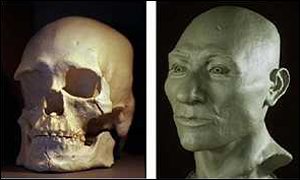
of objects: Kennewick Man from the PBS NewsHour with Jim Leher: A man with a stone spear-point in his right hip is currently
the subject
of an ugly court battle in Portland, Oregon. The human remains known as Kennewick Man are named for the town in eastern Washington State where he was found in 1996. Two speedboat racing fans stumbled across his skull on the banks of the Columbia River while watching a race. They reported the skull to police, who found more bones nearby. The local coroner and an anthropologist were called in to help solve the mystery of the bones' past. The anthropologist examined the site where the remains were found. He studied the height, skull shape and jaw of the skeleton. His first guess was that the skeleton belonged to a pioneer from the 1800s who died in his 40s or 50s. But another scientist said the spear-point in the hip looked older -- at least 5,000 years older. Then a scientific laboratory using a carbon dating test put the bones at 9,000 years old. That test set off a legal battle about who owned the remains. Who owns the bones? The Army Corps of Engineers, an agency of the U.S. government, was in charge of the site where the bones were found. The Corps decided that the remains should be turned over to the region's American Indian tribes in accordance with a 1990 federal law on Native American rights. They argued that anyone living in America 9,000 years ago (way before Christopher Columbus) counts as Native American. The Umatilla, Nez Perce, Yakama, Colville and Wanapum tribes all claimed Kennewick Man as an ancestor and said they planned to rebury the bones. But before the remains were handed over, eight leading
scientists sued
the government to stop the transfer. They wanted the right to study
Kennewick
Man, which they said could provide vital clues about the earliest human
settlers in the Americas. They said the government hadn't proven
Kennewick
Man was really related to the modern day tribes who claimed him. By a judge's order, government experts studied Kennewick Man for three years to see if he was related to the modern tribes. They looked at archaeological and biological information, but also researched the history and traditional stories of the modern American Indian tribes. Finally, in fall 2000, the Department of the Interior ruled that Kennewick Man should be given -- with no further scientific study -- to the Native American tribes for reburial. The department said Kennewick Man was a Native American by definition and that most of the evidence showed he was culturally affiliated with the tribes in the area today. But the scientists aren't convinced that Kennewick Man is related to the modern tribes, and their lawsuit resumes next week. They argue the government hasn't properly studied the remains. And they're concerned the law that returns early remains to Native Americans may be too broad -- it might hinder research on the first people to live in the Americas. The scientists, who are from the Smithsonian and several universities, say Kennewick Man is especially important because he's so old and his skeleton is almost complete. His discovery comes at a time of great uncertainty about who the first Americans were and where they came from, and the scientists don't want to lose this opportunity for what could be breakthrough findings. The First Americans: How Did They Get Here? Until recently, most experts thought the first Americans were big-game hunters who migrated from Siberia across a land bridge to Alaska at the end of the last Ice Age about 14,000 years ago. They traveled south and settled all over North and South America. But anthropologists and archaeologists are now finding evidence that people lived in the Americas much earlier, maybe 20,000 or even 30,000 years ago. There are also signs that humans lived on the Pacific Coast long ago. Could the first Americans have arrived from Asia and worked their way south by boat? Some researchers also see a resemblance between early American and European stone tools. Did some of the first Americans come from across the Atlantic Ocean? These are some of the questions scientists hope Kennewick Man can help answer. They say he holds clues about his physical traits, health, and lifestyle that can lead to a better understanding of the first Americans. The American Indian tribes, however, see the scientists' claims for Kennewick Man as another in a long history of exploitation of Native American bones. The 19th century is especially notorious for Indian grave-robbing: scientists, hobbyists and museums eagerly sought and paid for artifacts and bones from Indian graves for their early-America collections. They say the Kennewick Man case could reverse the progress Native Americans have made in protecting the legal and treaty rights they have historically been denied." Latest information suggests that the Kennewick man might be of asian origin, specifically, the ancient Ainu people of Japan-- Japan's earliest residents-- read more about the Ainu at the Ainu-Museum website
read National
Park Service reports on Kennewick Man The Future of Archaeology Questions About Our Past We will always face important issues regarding: Archaeological Science: Pure or Applied? Applied Archaeology The Garbage Project
The project has involved hundreds of students and 60
participating organizations,
recording more than 2 million items from 15,000 household refuse
samples
from some 250,000 pounds of garbage. The Garbage Project: Landfills Forensic Archaeology Disaster Archaeology Archaeology and Education Such archaeological programs bring people of different backgrounds together and break down social, ethnic, racial, and cultural walls that divide the world. Africa: A History Denied (a film)
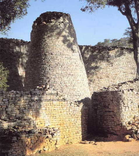
Cloaked in darkness since medieval times, the spectacular ruins of the once dazzling, southern African kingdom of Great Zimbabwe posed a thorny dilemma for white settlers who claimed to have “discovered” the region a mere hundred years before. Refusing to believe the massive, finely hewn stone walls could be the product of native culture, white “experts” eager to claim the land for Europeans credited the ancient city to everyone from wandering Phoenicians to the biblical Queen of Sheba. In so doing, they began a long, insidious European tradition of willful misinterpretation of Africa’s past, until, in the ultimate irony, the place where human history began would become a place with no history of its own. Now, trek inland to the remote site of Great Zimbabwe, a
fabulous “lost
city,” which reached the height of its glory in the 14th century. Then,
sift through the sands of time to uncover the equally splendid culture
of Africa’s Swahili Coast. The fabulously wealthy center of the
thriving
gold and ivory trades until the 16th century, its cities now lie all
but
forgotten, buried under centuries of indifference. Reclaiming their
past
from a long tradition of racial prejudice and neglect, the descendants
of these lost cultures are only now discovering the extraordinary
achievements
of Africa’s indigenous civilizations.
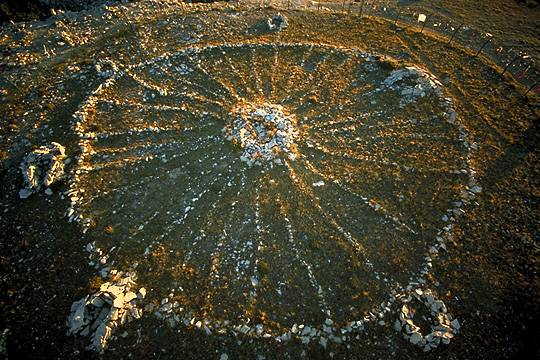
Rediscovering Ancient Technology Recreating Raised Field Agriculture They persuaded some local farmers to rebuild a few of the raised fields, plant them in indigenous crops, and farm them using traditional methods. The "Green Revolution," which attempted to impose inappropriate western crops and techniques in the Andes, had been a miserable failure. The archaeological evidence suggested that raised fields might be more appropriate for the region. The technology was indigenous to the region and it had been successfully used by farmers in the distant past. On a small scale, the experiment was considered successful, and today, some farmers are once again using the technology of their ancestors to produce food. Recently, Clark Erickson discussed his work in the Andean highlands and his new project in the Bolivian Amazon. Medicine Wheel of Wyoming's Big Horn Mountains Protection of sites is illustrated by the Bighorn Medicine Wheel--- thousands of tourists visitng the site for solstice activities threatenend the site's very existance. Now one must hike over a mile to get to the site-- an innovative method to control accees! Note paragraph at the end of this description of the site from codywyomingnet.com "Mystery and intrigue surrounds the famous Medicine Wheel of Wyoming's Big Horn Mountains. The Medicine Wheel is located on a plateau and sits at an elevation of 9,956 feet. The view from the top yields panoramas of the Bighorn Basin, the Wind River, the Absaroka Range, and the Pryor Mountains. The Medicine Wheel measures 80 feet across, and consists of 28 rock spokes that radiate from the center. There are 6 carins that are scattered on the outside of the wheel's rim. No one knows the true origin or purpose of the Medicine Wheel. Prospectors discovered the Medicine Wheel around 1885, however carbon-14 dating done on a piece of wood used in the construction of one of the carins dates back to 1760. Today, scientists and archeologists believe that the Medicine Wheel was created between A.D. 1200 and 1700 by Native Americans. There are many theories that explain the intended purpose of the Medicine Wheel. Some archeologists believe that the 28 spokes represent the 28 days in a month, and two of the 6 carins mark the horizons of sunrise and sunset, while the remaining four mark the rising of the three brightest stars. Other archeologists claim that the Native Americans who built the Medicine Wheel had no use for an organized calendar because they were not farmers. These archeologists believe instead that the Medicine Wheel carried religious significance and was used in religious ceremonies. Still other archeologists believe that the Medicine Wheel was a place for powerful events to take place and that people visited the sacred site to gain strength and power. Whatever the Medicine Wheel was originally built for, it has been used as a place of prayer for many Native Americans. Chief Joseph of the Nez Perce tribe was known to fast at the Wheel, while Chief Washakie of the Shoshone tribe claimed to have obtained his medicine there. The road that leads up to the Medicine Wheel itself, from the
interepretive
site, no longer permits motorized vehicles, except for handicap
accessibility.
You will have to walk the last 1.5 miles, so bring a lot of water.
Forest
Road 12 is often closed due to snow until mid-late June. The Medicine
Wheel
is closed for short periods for Native American ceremonies. A fence
surrounds
the Wheel and Native Americans have placed prayer cloths along with
other
sacred symbolic items on the fence. It is expected that visiting
tourists
respect these items and not disturb them." Who owns the past?
Who should own the past is a difficult question to answer. Who should have access to archaeological information? One thing for sure is that there is a danger that in owning the past, one tends to interpret it in highly biased ways. The worst offenders at purposeful misinterpretation of archaeological data goes to the Nazis, who used data to "prove" false allegations about the origins of the "gewrmanic" race, and to spread lies about other people, such as Jews, Gypsies, anyone who was not a memeber of the germanic Aryan race. Should some places be set aside because they are of religious significance to a minority number of people? What are the "correct" parameters to apply to this problem? The future of archaeology depends upon creation of innovative answers to ethical problems as well as academic problems. Hopefully, archaeological programs and projects will continue to be created that is inclusive of all social, ethnic, cultural and racial ideas and will serve to bring us all together. |
Links to Class Lecture Notes
| Introduction to Anthropology |  |
|
| Main College Index | |
| Gallery | Latest Finds | Book Review Index | Report Typos |


 m
mmmm
m
mmmm
